Frequently Asked Questions (FAQs)
FAQs
-
Password Resets and Changes
If you've lost or forgotten your password, click the "Reset Password" link on the Adapt-N login page. This will guide you through the process of obtaining a new password. If you need further assistance, please email support@agronomic.com.
To change your password:
- Click on the link for Settings in the left hand navigation panel
- Under My Settings click on the Change my password link
If you are an admin and need to change the password of an account under you, visit the Resetting User Passwords and User Deactivation page.
-
Deactivating Users
Billing admins have the ability to deactivate users in their system. To deactivate users, visit the Resetting User Passwords and User Deactivation page.
-
Importing Shapefiles
Importing Shapefiles
Fields can be quickly created in Adapt-N by importing a Shapefile created by one of many software systems. The process is as follows:
- Create a Shapefile for either a single field at the field level or multiple fields at the farm level
- Confirm that the three core files -- .shp, .shx and .dbf -- are included
- Zip these files together (see How to Create a Zip File)
- On Adapt-N's Land tab, drag the zip file onto the Create Field drop zone
- Within a few seconds, the imported field should be displayed on a map if it is a single field import or it will take you to another window were you can select the fields you wish to import
- Select (or create a new) farm and specify field name, and click Submit. Multi-field imports will take a couple minutes and the progress box will say when the import is finished.
Additional Notes
- Additional Shapefile file types, such as .prj and .sbn, may be included in the zip file, but will be ignored during the Adapt-N import process.
Error messages
"Invalid shape file, shp, shx, or dbf files missing." - Generally this means that the imported zip file does not contain the three required files, .shp, .shx, and .dbf. If all three files are present in the zip file, it is likely that those files are not properly formed. Attempt to re-export the Shapefiles from the original source, or contact support for further assistance.
-
How to Create a Zip File
In order to import shapefiles into Adapt-N you must first compress or zip them; instructions for both PC and Mac are below. At minimum you must have the DBF, SHP and SHX file types.
On a PC:
- Highlight all three of the required files (DBF, SHP, SHX) with your mouse
- Right click on any of the highlighted files
- Hover over Send To in the pop-up menu
- Select Compressed Zip Folder from the 2nd pop-up menu
- Name the file that was created and hit Enter, this is the file that you will drag and drop into Adapt-N via the browser window
On a Mac:
- Highlight all three of the required files (DBF, SHP, SHX) with your mouse
- Right click on any of the highlighted files
- Select Compress 3 Items from the pop-up menu
- A new zip file named Archive.zip will appear, this is the file that you will drag and drop into Adapt-N via the browser window
-
Weather data summary
The Adapt-N platform utilizes data from several high-quality weather data providers. Our models automatically incorporate daily inputs for temperature, precipitation, and solar radiation at a 4 km (approximately 2.5 mile) resolution or greater. These data are captured from a combination of radar estimated and ground observational sources, with trusted methods for extending observations to areas where no physical weather stations exist. The Adapt-N research team regularly evaluates the accuracy of different weather providers and identifies the most appropriate source(s) for each service region. Some customer implementations also have the option to utilize on-farm weather stations when they exist within 0.5 km of a field.
New climate data is acquired several times per day, and the associated rainfall amounts shown on the recommendation page are updated without delay (although in some cases they are error-adjusted as additional stations report ground readings, so they may change slightly in the first 24-48 hours after the event). However, since Adapt-N is simulating what's actually happening in a field in real-time, it can take up to 3-4 days for the effects of that precipitation to fully impact a recommendation in a meaningful way. In the case of leaching, for example, it can take 1-2 days for the water to move through the soil profile; for denitrification, it takes a few days for the soil to go into an anaerobic state. Adapt-N models these impacts and adjusts the recommendations accordingly, and of course these rates will differ depending on soil type, rooting depth, slope, and other factors.
A good rule of thumb is to review the recommendation 3 full days after a rainfall event ends.
-
Which states are supported in Adapt-N?
Adapt-N’s current service area includes all of the lower 48 US states and the Canadian Provinces of British Columbia, Alberta, Saskatchewan, Manitoba, Ontario, and Quebec.
If you try to create a field in a state that is not supported you will see an error like this:
Getting Started
Getting Started Guide
-
Free Adapt-N Self-Guided Training Course
Free Adapt-N Training Courses are available by visiting https://adapt-n.teachable.com/
-
Adapt-N Basic Training Video
-
System Requirements
Adapt-N is a cloud based tool that runs through a web browser.
Minimum Supported Browser Version Operating System Firefox Internet Explorer Chrome Safari Windows 7 or Higher 52 or higher 11 or higher 57 or higher N/A
OS X 10.10 or higher 52 or higher N/A 57 or higher 10 or higher Mobile-optimized version for iOS and Android coming soon.
-
Logging In
Visit http://www.adapt-n.com/ and click the blue login button. Or bookmark https://adaptn.agronomic.com/login.html in your browser.
-
Data Organization Overview
Data in Adapt-N is organized based on the following hierarchy:
- Grower Account: an entity corresponding to a grower whose fields will be contained within the farms inside this Grower Account.
- Farm: a grouping of fields within a Grower Account.
- Field: a boundary within a Farm.
- Zone: a sub-part of a Field. Each field must have at least one zone, but may have many zones.
-
User Types
Each user with a login/password to Adapt-N fits into one of the following roles:
- Billing Admin: the administrator of the Adapt-N account, with access to all functions within the account, including the ability to create and manage other users.
- Agronomist: a user created by the Billing Admin, with access to create, configure, and activate fields on behalf of one or more Grower Accounts. Agronomist users do not have access to create or manage other users nor can they access account billing information. In certain cases, they can create and manage Grower Accounts (but not users).
- Grower Login: a user created by the Billing Admin, with access to a single Grower Account only. Grower Login users can have the ability to activate fields if granted that functionality. They can see and manage data within their own account. Note: by default, Grower Accounts (the first level listed in the Data Organization hierarchy above) do not have a Grower Login associated with them; these need to be explicitly added by the Billing Admin to grant the grower login access.
User Settings
Your Settings
-
Password Change or Reset
If you've lost or forgotten your password, click the "Reset Password" link on the Adapt-N login page. This will guide you through the process of obtaining a new password. If you need further assistance, please email support@agronomic.com.
To change your password:
- Click on the link for Settings in the left hand navigation panel
- Under My Settings click on the Change my password link
-
Updating Your User Information
To change user information such as name, email, phone number, and field activation rights:
- Click on the link for Settings in the left-hand navigation panel
- Under My Settings click on the Change my profile link
-
Nitrogen Alert Settings
To change your individual alert preferences:
- Click on the link for Settings in the left-hand navigation panel
- Under My Settings click on the Change my profile link
- Set your preferences (see below for explanations):
Explanations:
- To turn Email Alerts and/or Text Message (SMS) alerts on, check the appropriate box under Alerts Enabled
- Select at least one day to receive the email and/or Text alerts by checking the box next to the desired day(s)
- The Alert Start Date and Alert End Date boxes control the first and last day in the season during which you would be eligible to receive alerts.
- When enabled, "Show detailed zone data" options cause the alert emails to list out each individual zone that crosses the N-Alert Threshold. When not set, a summary of all zones in the field crossing the threshold is provided instead. These options exist for Point and Zone-based fields only, as Grid-based fields are always sent as a field summary.
Click the Update User button to save your settings
Don't forget to add alerts@agronomic.com to your email safe list so your alerts don't end up in your spam folder.
Alert Threshold
The N-Alert Threshold controls which zones and fields will be included in alerts. Only current day recommendations that meet or exceed the threshold will be sent.
Billing Admin users and Agronomist users who have permission to manage the Grower list can modify the N-Alert Threshold for Grower Accounts as follows:
- Click on the link for Settings in the left-hand navigation panel
- Under Admin Access click on User List, and then the Update link for the Grower Account you'd like to modify
- Enter the number of lbs N/acre desired in the Nitrogen Alert Threshold field
- Click the Update Grower button to save your settings
Alerts will be delivered to users according to their alert schedule, when any zone in their account has a recommendation equal to or higher than the specified threshold. To receive alerts regardless of current recommendation levels, set the Grower Account threshold to 0 (zero).
Here is a sample email alert:
-
Integration Settings
To manage settings for any integrations supported by Adapt-N:
- Click on the link for Settings in the left-hand navigation panel
- Under My Settings click on the integration you wish to manage
If you don't see the integration you are looking for, contact support@agronomic.com for assistance.
Admin Access
-
Resetting User Passwords and User Deactivation
Resetting Passwords and Deactivating Users
To reset a user's password, navigate to the User List and click "Change Password". Enter a new password, and optionally indicate whether or not that user should be forced to change their own password upon their next login.
To deactivate a user, click the "Deactivate User" button in the User List. This causes the user to be logged out of Adapt-N. Nitrogen Alerts will no longer be sent to that user. They will not be able to login again unless reactivated by a Billing Admin.
-
Creating Agronomist Users, Grower Accounts, and Grower User Logins
Accounts for Agronomists
Agronomist Users can be created by Billing Admins and can be given access to manage some or all of the Grower data within the organization.
To create an Agronomist User:
- From the User List page, click on Add Agronomist
- Enter the requested information on the Add User page (all fields are required)
- Click Add User
- Note that the user is not automatically notified about their credentials; they should be provided directly by the Billing Admin
- To grant agronomist access to some or all of the growers in the account, use the arrows to move the desired growers to the "Access Granted" side of the box. The double arrows will move all the growers in the organization from one side to the other. To move a single grower, click the grower name you wish to move and then click the single arrow to move that grower to the desired side. To move groups of growers, hold shift and select multiple growers before clicking the single arrow and that group of growers will move to the desired side. To request this feature in your account, email support@agronomic.com
Accounts for Growers
A Grower Account is a place to hold information about a particular grower or producer and will include all the Farms and Fields loaded into Adapt-N for that grower.
A Grower User Login can optionally also be created and associated with a Grower Account, giving the Grower access to their own farm and field data. A Grower User can only be associated with one Grower Account, thereby limiting access to that specific grower's fields. Billing Admins in each organization can create and manage User Logins.
User Logins for Growers can view and modify data associated with farms and fields within that Grower Account. These users cannot access or modify any information relating to billing information or other grower accounts. Grower Users can optionally activate fields if given Field Activation Rights by the an Agronomist or Billing Admin user. Grower Users can also modify delivery preferences for Nitrogen Alerts, but they cannot modify the Nitrogen Alert threshold.
To create a Grower Account:
- Login to your Adapt-N account
- On the Navigation Bar, click on Settings
- On the Settings page, click on User List
- On the User List page, click on Add Grower Account
- Enter the requested information on the Add Grower page (name and zip are required) and click Add Grower
If you also want to enable login access for that Grower Account, continue on and create a new User login:
- From the User List page, click on Add User next to any existing Grower Account
- Enter the requested information on the Add User page (all fields are required)
- Click Add User
- Note that the user is not automatically notified about their credentials; they should be provided directly by the Billing Admin
-
Billing Summary
For information on account usage, account properties, and billing details:
- Click on the link for Settings in the left-hand navigation panel
- Under Admin Access click on the Billing Detail link
- The Billing Summary is viewable to the Billing Admin only
-
Modifying Recommendation Parameters
The assumed price of grain, cost of nitrogen, and pounds of nitrogen needed per bushel of expected yield can be modified to further tailor Adapt-N to a grower's specific market and growing conditions.
Crop and Nitrogen Prices
Adapt-N uses a correction factor (Correct_profit) in the N rate calculation that accounts simultaneously for the relative prices of fertilizer and corn, and the higher relative risks associated with under-prediction versus over-prediction of the optimum nitrogen rate. The downside risk is higher due to greater cost from yield loss than excess fertilizer application. Since Adapt-N recommendations are more precise than conventional static recommendation systems, they are less sensitive to fluctuations in price ratios of fertilizer and crop because downside risks are reduced.
Pounds of Nitrogen Needed per Bushel of Expected Yield
Each zone's yield goal causes the "Expected N in crop at harvest" value to be set during the recommendation process. This is essentially what Adapt-N uses as the end of year target for how much N needs to be in the crop. Administrators can change the pounds of N needed per expected bushel of yield, to directly modify this value.
Setting Recommendation Parameters
Administrators have the ability to change the default values both organization-wide and at the individual Grower Account level. In the absence of parameters being set at the Grower Account level or Company-wide level, Adapt-N system defaults will be used, which are updated from time to time. Here is the logic as to which parameters get used:
To modify these values:
- Navigate to Settings
- To set parameters Company-wide, click "Modify Recommendation Parameters"
- To set parameters for a Grower Account, visit the User and Grower list, and click the
 icon next to the account name, or use the "update" and click "Modify Recommendation Parameters"
 - Set the appropriate values. Notes:
- the acceptable grain price is between 5 and 18 times the price of N per pound
- the allowable range for pounds of N per expected bushel of yield is 0.6 to 1.4
- the $/pound of Nitrogen is a generic value for a pound of nitrogen, not for a unit of product
Viewing Results
- When anything other than the Adapt-N system defaults are used for a recommendation, an additional line will be displayed showing those parameters.
- The recommendation itself is automatically adjusted to take the modified parameters into account.
-
Managing Custom Fertilizers
Billing Administrators have the ability to create custom fertilizer products for use when adding existing N applications and exporting Adapt-N nitrogen recommendations. All users in an account will have access to such products. To access the Custom Fertilizers page, click Settings -> Modify Fertilizer Products.
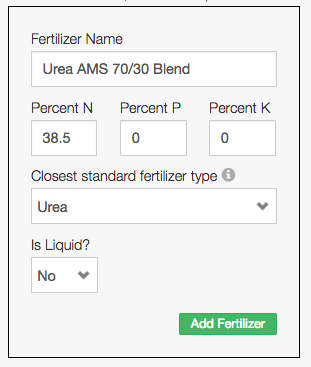
To create a product for use in Adapt-N, the percentages of N, P, and K will need to be specified. If the product is a liquid, its weight in pounds per gallon will also need to be provided. Additionally, the closest standard fertilizer product must be selected, so that Adapt-N can appropriately model the effects of that form of nitrogen when applied in the field. Administrators can enable or disable custom fertilizers, which determines whether users in their account see the fertilizer on the Zone Nitrogen, Field Configuration, and Field Recommendation Export screens.
If the new custom fertilizer represents a blend of more than one fertilizer product, it's important to properly calculate the blended percentages of N, P, and K, so the exported recommendation is properly converted. Here are some examples:
Example 1, Solid Fertilizer: 70% Urea and 30% AMS
- Urea (46-0-0) at 70% = 32.2% Nitrogen
- AMS (21-0-0-24) at 30% = 6.3% Nitrogen
- The addition of the nitrogen components = 38.5% Nitrogen
The specification of this blended product in Adapt-N would be:
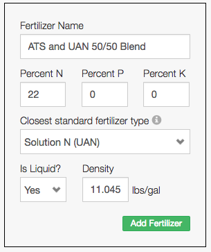
Example 2, Liquid Fertilizer: 50% Ammonium Thiosulfate and 50% UAN
- Ammonium Thiosulfate (12-0-0-26) at 50% = 6% Nitrogen
- UAN (32-0-0) at 50% = 16% Nitrogen
- The addition of the nitrogen components = 22% Nitrogen
Liquid products also require a specified weight per gallon. For blended products, perform a similar calculation based on the individual product weights per gallon combined with their percentage blend in the overall custom fertilizer:
- Ammonium Thiosulfate (11.01 pounds per gallon) at 50% = 5.505
- UAN (11.08 pounds per gallon) at 50% = 5.54
- The addition of the product weights = 11.045 pounds per gallon
The specification of this blended product in Adapt-N would be:
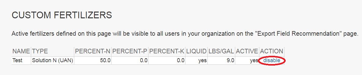
Customer fertilizers can then be enabled and disabled by the Billing Admin. When enabled, the custom fertilizer will be visible to everyone in the Billing Admin's organization.
Special Note for agX Platform Users
When exporting a recommendation to agX, users must choose from a Custom Fertilizer which was imported from agX. These are set up and managed using a Proagrica/SST Software product, such as Summit.
Dashboards
Grower Dashboard
-
Grower Dashboard
The dashboard is a great way for a grower to efficiently see the current status of all fields in the their account. The following categories are summarized;
- Total Lbs of N Currently Needed
- # of Zones Calling for Nitrogen
- # of Zones NOT Calling for Nitrogen
- Maximum Recommendation (Lbs of N/Acre)
- Average Recommendation (Lbs of N/Acre)
- Minimum Recommendation (Lbs of N/Acre)
In addition, a grower can see a detailed list of all farms, and fields activated. This list includes the following details for each field;
- Growth Stage
- Current Recommendation (Min/Avg/Max)
- Past Applications - Total Lbs N (Min/Avg/Max)
Account Administrator & Agronomist Dashboard
-
Account Administrator & Agronomist Dashboard
The dashboard is a great way for an account admin or an agronomist to efficiently see the current status of all fields in the account. The following categories are summarized:
- # of Growers Setup
- # of Growers Needing Nitrogen
- # of Active Fields
- # of Inactive Fields
- # of Active Fields Without Zones
- Maximum N Recommendation
- Minimum N Recommendation
- # of Fields Above N Alert Threshold
In addition, billing admins and agronomists can see a detailed list of all growers, farm, and fields activated. This list includes the following details for each field;
- Status of Field Configuration
- Activated Acres of Each Field
- Growth Stage
- Current Recommendation (Min/Avg/Max)
- Past Applications - Total Lbs N
Data Connections and Integrations
Adapt-N / N-Insight API
-
Using Adapt-N through the Agronomic Technology Corp API
Agronomic Technology Corp provides a full service REST API for customers and partners who wish to leverage Adapt-N and N-Insight in their own software interfaces. For current documentation, developer access, pricing, and support, please contact support@agronomic.com.

Agrian Software System
-
Using Adapt-N with the Agrian software system
Linking an Adapt-N account with the Agrian software system

Agrian's software system provides users with a full suite of agronomic data management tools. Your Adapt-N account can be connected with Agrian's software, enabling various data to automatically be populated in Adapt-N, streamlining the field configuration process.
Overview Video
Linking your Adapt-N account to your Agrian account
Follow these steps:
- Login to Adapt-N at www.adapt-n.com, by clicking the Login link in the upper right.
- Click on Settings in the navigation bar, and select Agrian Settings.
- Click the “Authenticate with Agrian” button. You will then be prompted to authenticate using your Agrian credentials (the same information you use to login on Agrian's website). Complete the steps as prompted.
Your Adapt-N account has now been granted access to data from your Agrian account. The above steps are generally a one-time process for new Adapt-N accounts. In the event that your authentication with Agrian expires, you may be prompted to re-authenticate. Note that the linkage between an Adapt-N and Agrian account occurs at the user level, not at the grower, farm, or account level.
Generating Adapt-N recommendations using Agrian source data
Using Agrian data as a source for Adapt-N recommendation involves 3 broad steps:
- Importing the Agrian Grower into Adapt-N (this makes the Grower’s fields available to Adapt-N for selection in the next step).
- Importing individual Fields from that Grower into Adapt-N (this creates the Grower/Farm/Field relationship in Adapt-N and pulls in the field’s boundary and optionally zone geometries). Single field and bulk import options are available.
- Configuring the fields and producing the Adapt-N nitrogen recommendation (this sets the necessary information for Adapt-N to run a recommendation, including tillage method, planting information, soil test results, etc.).
Detailed instructions on these steps
Importing the Agrian Grower into Adapt-N
To import a Grower from Agrian into Adapt-N, find the Grower in the list at the bottom of the page, select "Create as new grower," and press "Import". This will cause the Grower's fields to become available on the "Fields" tab of the Agrian Sync page. You may optionally import all Growers at once.
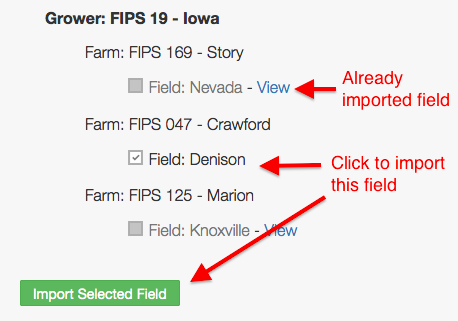
Importing a Grower’s Fields into Adapt-N: one field at a time
On the Fields tab of the Agrian Sync page, select a Grower whose field you wish to import. Check the box for the appropriate field and click the Import Selected Field button at the bottom of the page.
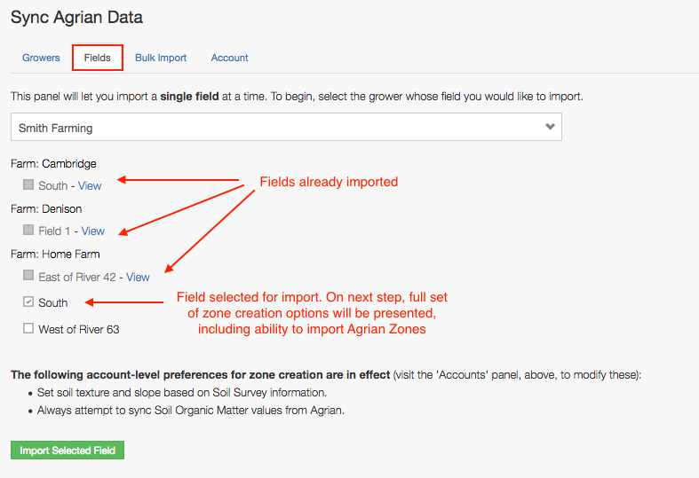
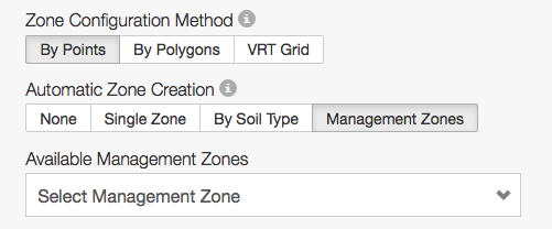
The field's boundaries will then be displayed, along with the Farm and Field name as found in Agrian. Select an appropriate Field Mode and Automatic Zone Configuration Option and click submit. If Management Zones have been created in Agrian, then an "Agrian Zones" option will also be displayed:
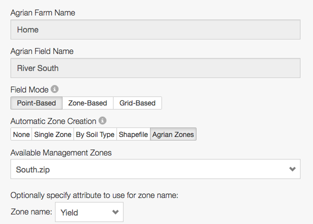
If you select Agrian Zones, then a list of available management zones will be displayed. You can optionally choose an attribute from those management zones to use for zone names in Adapt-N. If this option isn't specified, zones in Adapt-N will be named "Zone 1", "Zone 2", etc.
Importing a Grower’s Fields into Adapt-N: Bulk import option
On the Bulk Import tab of the Agrian Sync page, select a Grower whose fields you wish to import. You may also select an option to display all Growers' fields. Check the boxes for each field you wish to import, then fill out the form below. Field Mode and Zone Creation option are required; all other values are optional. The values you select will apply to all fields during the import. Note that field-specific Agrian zones cannot be utilized via the Bulk Import tool.

Configuring the fields
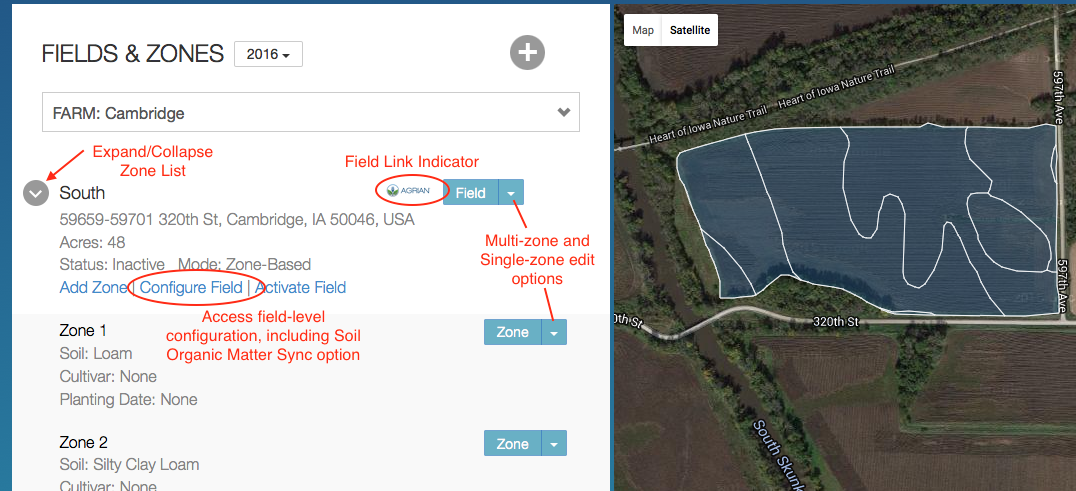
Once a field is imported, the Map View in Adapt-N displays a field link indicator, showing the source system for each field. Click on "Configure Field" to access the Variable Rate field configuration page. Or, use the Field and Zone menus to edit one or more zones details.
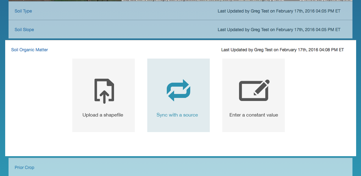
Soil Organic Matter Sync
Once a field is imported, Adapt-N automatically imports the most recent Soil Organic Matter test for the field (as long as that test is within the last 5 seasons). You can also manually sync the most recent soil test, or import Soil Organic Matter data via shapefile or constant value, from the Configure Field tool:
Additional Information:
Currently, the Agrian integration supports the import of Growers, Farms, Fields, Field Boundaries, Management Zones, Soil Organic Matter, and pH test results into Adapt-N. Additional features will be added down the road.
agX
-
Using agX as a Data Source for Adapt-N Field Configuration
agX can be used as a data source to configure variable rate fields in Adapt-N. Different sync options exist depending on the zone management field mode . For information on linking an Adapt-N account to an agX Platform account, please visit this page.
Point-Based and Zone-Based Fields
When importing an agX field into Adapt-N, if Management Zones exist for the field in agX, an additional Automatic Zone Creation method will become available. When selected, a drop-down list will let the user choose from a saved Management Zone set in agX to use for creation of Zones in Adapt-N:
Select the desired Management Zone option and complete the field import. An Adapt-N zone will be created for each agX Management Zone. If present in agX, the Yield Goal for each zone will be also be applied to the new zones. If the Management Zones are named in agX, those names will be used in Adapt-N, else zones will be numbered. In all cases, when Management Zones are used, soil texture, slope, drainage class, and rooting depth will be set automatically (but may be adjusted by visiting the Land Details page for each zone).
Grid-Based Fields
When configuring a Grid-Based field in Adapt-N, layers with agX sync capabilities will have a "Sync with a Source" option presented.

Soil Type and Soil Slope: by default, Soil Type, Slope, drainage status, and rooting depth for the field values are automatically set based on Soil Survey data during field import. These values can be overridden from the Field Configuration screen. Default values on the Sync with a Source screen are optional, and will only be utilized in parts of the field where the Soil Survey database lacks sufficient information.
Soil Organic Matter: by default, the most recent soil test results from the past 5 seasons will be used to automatically set the Soil Organic Matter configuration for fields up on import. If the soil sampling operation in agX is polygon-based, the Adapt-N field's organic matter values will be configured based on those sampling polygons. If the sampling operation in agX is grid-sampled, Adapt-N will automatically interpolate those values as necessary.
Expected Harvest Population: when Sync with a Source is selected, Adapt-N will display all available datasets containing planting rate information, including some basic statistics about those planting records. The default value is optional, and will only be used in cases when the selected agX data does not cover the entire field. This includes:
- Crop Establishment and Input (CEI) Applications
- Crop Establishment and Input (CEI) Recommendations
Adapt-N takes 90% of the seeding rate for use as Expected Harvest Population
Expected Yield: when Sync with a Source is selected, Adapt-N will display all available datasets containing yield goal information, including some basic statistics about those records. This includes:
- Crop Establishment and Input (CEI) Applications
- Crop Establishment and Input (CEI) Recommendations
- Management Zones containing yield goal information
Regardless of which data source is selected, the Maturity Class and Planting Date controls must be specified in the Adapt-N interface, as these values will be used in all cases. The Default Expected Yield input is optional, and will only be used when a portion of the field lacks yield goal information in the specified dataset. Note that if Management Zones from agX are used during the field import process, yield goals associated with those management zones will be used by default, but can be updated by the user via the Configure Field interface.
Other Input Layers: can be set via constant value or Shapefile upload.
Bulk Import
Completed Recommendations
Adapt-N recommendations can be exported back to agX. See this article for details.
-
agX Bulk Import
Users with access to the agX integration will find a Bulk Import tab in their agX settings. This allows users to import multiple fields at once under a common field configuration. Once an import is initiated, a popup box will display progress and details. Please leave this window open until the import completes. Any errors will be displayed at the end of the process.
Please contact support@agronomic.com for additional questions or assistance with this feature.
-
Using the agX platform with Adapt-N
The agX Platform provides a geospatial infrastructure for a community of integrated ag products and services to seamlessly share data with applications authorized by its users. Adapt-N is an agX compliant application, enabling users to pull source data from products like Proagrica's Summit and Sirrus tools, and push Adapt-N recommendations back into those or other systems for application in the field. If you have an agX account but do not yet have an Adapt-N account, please register here.
Linking your Adapt-N account to your agX account
Follow these steps:
- Login to Adapt-N at www.adapt-n.com, by clicking the Login link in the upper right.
- Click on Settings in the navigation bar, and select agX Settings. You may also access this section by clicking “Import agX Grower” when choosing a Grower Account within Adapt-N.
- Click the “Initiate agX Connection” button. You will then be prompted to authenticate using your agX credentials, and to authorize Adapt-N to access your field boundaries and collected data. Complete the steps as prompted.
Your Adapt-N account has now been granted access to data through the agX Platform. The above steps are generally a one-time process for new Adapt-N account. In the event that your authentication with agX expires, you may be prompted to re-authenticate. Note that the linkage between an Adapt-N and agX account occurs at the user level, not at the grower, farm, or account level.
Generating Adapt-N recommendations using agX source data
Using agX data as a source for Adapt-N recommendation involves 3 broad steps:
- Importing the agX Grower into Adapt-N (this makes the Grower’s fields available to Adapt-N for selection in the next step).
- Importing individual Fields from that Grower into Adapt-N (this creates the Grower/Farm/Field relationship in Adapt-N and pulls in the field’s boundary geometries).
- Configuring the fields and producing the Adapt-N nitrogen recommendation (this sets the necessary information for Adapt-N to run a recommendation, including tillage method, planting information, soil test results, etc.). See this article for specific information on using agX as a data source for various input layers.
Detailed instructions on these steps
Importing the agX Grower into Adapt-N
To import a Grower from agX into Adapt-N, find the Grower in the list at the bottom of the page, select "Create as new grower," and press "Import". This will cause the Grower's fields to become available on the "Fields" tab of the agX Sync page.
Importing a Grower’s Fields into Adapt-N
On the Fields tab of the agX Sync page, select the field you'd like to import by checking the box next to the field name. Click the Import Selected Field button at the bottom of the page.
The field's boundaries will then be displayed, along with the Farm and Field name as found in agX. Select an appropriate Zone Configuration Method and Automatic Zone Creation option and submit the field.
Additional Tips:
The agX Data Sync page can be accessed from multiple parts of the Adapt-N interface:
- By clicking on the “Import agX Grower” option when selecting a Grower Account
- By clicking the “agX Settings” link within the Settings menu
- By clicking “Sync with a source” during the field creation process
All three of these take you to the same place.
The agX Sync page in Adapt-N is comprised of four tabs:
- Growers: this tab shows a list of all Growers in Adapt-N system (top, indicating which are linked to an agX Grower) and all Growers in agX that do not yet exist Adapt-N (bottom). To import a Grower into Adapt-N, use the “Create as new grower” menu item, then click the "Import" button to the right.
- Fields: this tab shows a list of the fields in agX for the imported Growers. A field with an available checkbox has not yet been imported into Adapt-N. A field with a disabled checkbox has already been imported into Adapt-N; click the link to view it in Adapt-N.
- Bulk Import: this tab lets multiple fields be imported simultaneously under similar field characteristics.
- Custom Fertilizers: this displays all Custom Fertilizers that exist in the user’s agX account. Check the boxes next to whichever fertilizers you would like available for us in exporting completed Adapt-N recommendations back to agX.
- Account: in the event that you receive an authentication error while using the agX integration, you may return to this page to re-establish your agX connection, or to view the agX account to which the Adapt-N account is linked.
See this article for details on how to import different layers of data from agX.
EFC Systems - FieldAlytics
-
Using Adapt-N with EFC Systems' FieldAlytics System
The EFC Systems FieldAlytics system has completed an integration with the Adapt-N API, enabling users to remain within the FieldAlytics interface to generate, view, and export Adapt-N recommendations and N-Insight reports. Please contact EFC Systems support for assistance.

John Deere Operations Center
-
Using Adapt-N with John Deere Operations Center
John Deere Operations allows users to quickly move data to and from Adapt-N. Your Adapt-N account can be authenticated with John Deere Operations Center using MyJohnDeere credentials.
Linking your Adapt-N account to John Deere Operations Center
Follow these steps:
- Login to Adapt-N at www.adapt-n.com, by clicking the Login link in the upper right.
- Click on Settings in the navigation bar, and select John Deere Operations Center Settings
- Click the "Authenticate with John Deere Operations Center" button. You then be directed to the MyJohnDeere page where you can enter the login credentials for the MyJohnDeere account. Complete the steps as prompted.
Importing Fields
Creating Fields
-
Creating Fields
Important note:
Users can create and manage other users in their Adapt-N account by clicking the Settings icon on the navigation bar and then clicking User and Grower List. In order to create a field, you must create a Grower Account for the field to reside. Grower Accounts are automatically created when fields are imported through integrated software systems. See this article for additional instructions.
Creating Fields
Select the “land” icon from the left navigation bar, then choose the appropriate Grower Account. If no fields already exist within the Grower Account, the user will be taken directly to a page with field creation options. If fields already exist, click the
icon at the top of the Fields & Zones list to add an additional field. Alternatively, fields can be created using an external data source, such as agX, Agrian, or John Deere Operations Center which can be found in Adapt-N settings. Depending on the Adapt-N account’s settings, one or more of the following field creation options will be presented:
- Drop a shapefile: drag onto the browser dropzone a zip file containing the .shp, .shx, and .dbf components of a field’s boundary shapefile. See this article for detailed instructions. Multi-field bulk import of fields via shapefile is now also supported.
- Draw on Map
- Sync with a source: if the user’s account is connected to an external data source, such as the agX Platform, an interface will load allowing the user to select one or more fields from the source system. If the user’s account has not yet been connected to an external data source, the user will be prompted to establish the connection (if the Adapt-N account is enabled for such access). See this article for detailed instructions.
Drawing Fields
To create a field by drawing it, click the land icon in the Navigation Bar. If no fields exist in your account, click anywhere in the "Draw on a map" circle:
If one or more fields already exists in your account, clicking the land icon will take you to your Farm View. To add a new field from here, click the "+" icon in the upper right of the Fields and Zones list:
Once inside the drawing application:
- center the map by entering an address, zip code, or GPS coordinates, and click "Center Map". Or, grab and move the map to locate your area of interest.
- zoom in to find the field of interest
- select from existing boundaries or draw new boundaries to create a field
Selecting from Existing Boundaries
Adapt-N pre-populates the maps with likely boundaries of existing fields. These are represented by a dark boundary outline. When your mouse hovers within those boundaries, the field darkens, such as:
To select a field, simply click within the boundaries. To select multiple boundaries to be treated as one field within Adapt-N, shift-click the additional desired field(s) (this functionality is not supported on touch devices). You may adjust the boundaries of any selected field by using the hand icon to grab and move the white angle points. For example:
You may also add custom drawn boundary components to selected existing boundaries by shift-clicking the polygon icon from the top of the page. (see Draw New Boundaries instructions in the next section)
Note: single clicking (without Shift) on the polygon drawing tool or single clicking on any existing boundary will clear all existing selections.
Draw New Boundaries
- to begin drawing, click the polygon tool icon in the top center of the map
- click and release the mouse to establish the first point in the field polygon
- move the mouse to the next desired point in the polygon, click and release
- continue this process to create a fully closed polygon
- to complete the shape, double click, or click on the first point of the shape; the field will turn red indicating that it is ready for submission
- you may optionally adjust any points by clicking the hand icon tool at the top of the page and grabbing and moving the white angle points
Once the desired boundaries have been specified, click "Submit Location" to complete save the field.
-
Field Setup
After importing a boundary your field will need to be named. If you imported a field boundary from a source, the field name will automatically match the field name from the source.
Users are also asked to choose a field mode and automatic zone creation setting.
Field Modes
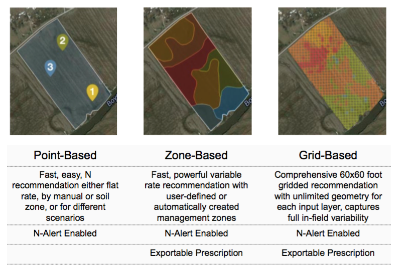
Adapt-N has three Field Modes supporting flexible zone management preferences.
Automatic Zone Creation
Zone Creation options are:
- None: no zones are automatically created. Use the "Add Zone" link to manually create zones after the field is created.
- Single Zone: a single whole-field zone is created. For point-based fields, this is represented as a single point placed roughly in the center of the field. For zone-based fields, a polygon is created matching the boundaries of the field.
- By Soil Type: a zone is created for each unique soil texture/slope/drainage combination in the Soil Survey database for the field. For both field modes, all soil texture, slope, drainage, and rooting depth parameters are automatically set during the import process. They can be manually adjusted by visiting the Land parameters for the zone after import. Note that Zone-Based (Polygon) fields for which the same soil texture/slope/drainage combination exists more than once in the field, a multi-polygon zone will be created as a single zone in Adapt-N.
- Shapefile: select a zipped shapefile to create zones based on the geometry from that shapefile. Optionally, an attribute (column) from that shapefile can be selected to be used to set each zone's name. An option also exists to consolidate all zones with the same name.
Point-Based and Zone-Based fields have all options available for Automatic Zone Creation. Grid-Based fields do not have user-defined zones, so no options are presented.
If the field was imported via a source system, such as agX, and Management Zones exist in the source system, a fourth Automatic Zone Creation option will be provided:
- Management Zones: the list of available Management Zone sets will be displayed, and zones in Adapt-N will be created to match the Management Zones from the source system. Soil texture, slope, drainage, and rooting depth parameters will be set automatically during the import process, but can be edited by visiting the Land parameters for the zone after import.
-
Adding Zones
Once you have uploaded or drawn a field you can add zones to it. Each field must have at least one zone. To do so, go to the Land tab and click the Add Zone link associated with the field you are working with.
For Point-Based Zone Fields
- Click anywhere on the map outside of the designated field to drop a pin.
- After dropping the pin, drag it into the desired location with the field.
- Enter the requested data and click the Add Zone button.
For Polygon-Based Zone Fields
- Click the polygon tool at the top of the page
- Click a point, then click to create another point to draw the zone boundary. Continue creating points until the polygon is closed, or double click to automatically close it.
- Optionally use the white points to make adjustments.
- Enter the requested data and click the Add Zone button.
-
Changing Field Modes
Adapt-N has three field modes for the creation and management of zones, enabling flexible configuration based on different usage preferences. When creating fields, you may select from any of the modes enabled for your account:

After a field has been created, you may optionally switch to another mode by viewing the Fields & Zones (map) page, clicking the Field menu, and selecting Change Field Mode:
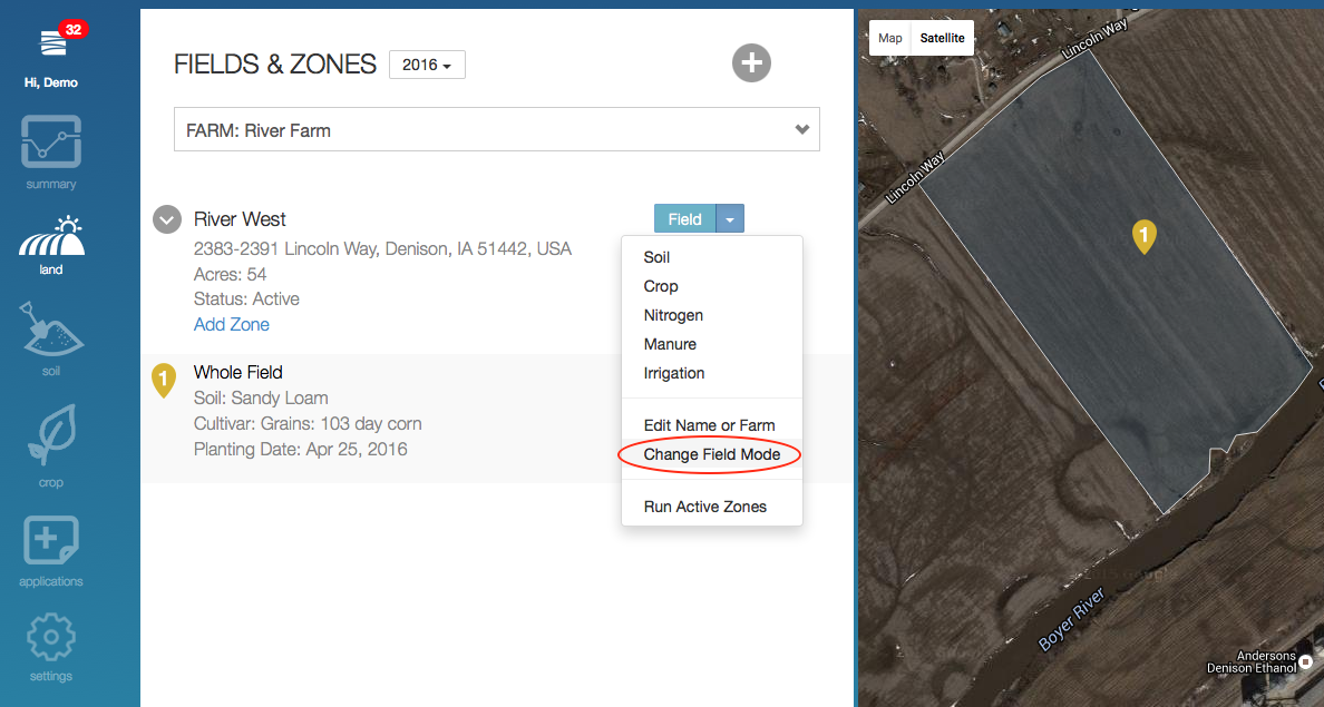
The next screen presents the options for choosing a new field mode, and also lets you choose whether to delete the previous version of the field or not. In this example, the existing field version is point-based and the user will change it to polygon-based:
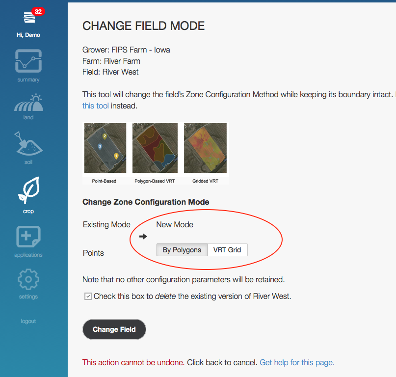
Important note: this process keeps the existing field's boundaries intact. Since the fundamental representation of the zones is changing, no data associated with old zones (such as yield goal, planting date, etc.) will be carried forward to the new zones. This includes the zones themselves, which will need to be added via any of the supported methods available for new fields.
Once the user clicks Change Field, the new field is displayed in the Map View. From here, create/manage zones and configure the field just as if it had recently been created.
If the existing field is Activated and it is marked for deletion during this process, the new field will automatically be Activated. No additional acreage charges will occur. If the existing field is Activated but it is not marked for deletion, it will remain Active and the new field will be Inactive. The user will need to explicitly Activate the new field to create in-season recommendations. If your intention was to replace the old field and deactivate it, but do not want to delete it permanently, please contact support for assistance.
Configuring Fields
Variable Rate Field Configuration
-
Variable Rate Field Configuration
Adapt-N's full-field variable rate prescription feature provides powerful nitrogen recommendations that are weather-adjusted, site-specific, and account for substantial sub-field variation. Just like with any other Adapt-N recommendation, users can control various inputs and can analyze the makeup of the recommendation before deciding exactly what to apply in the field. Service Provider, Enterprise, and Precision Trust licenses may request access to the Variable Rate features by contacting support@agronomic.com.
Creating a Field for Variable Rate Purposes
Variable rate prescriptions may be generated by importing a Shapefile or by syncing the field boundaries to a data source, such as the agX Platform (see instructions here). Fields drawn by hand within Adapt-N are not eligible for variable rate prescriptions due to the precision needed to appropriately utilize the recommendation. Shapefile imports should be conducted for a single field, although multiple polygons within that field are supported. Full instructions on importing field boundaries using Shapefiles are located here.
Once a field boundary has been imported into Adapt-N, select the "VRT Grid" zone creation method:
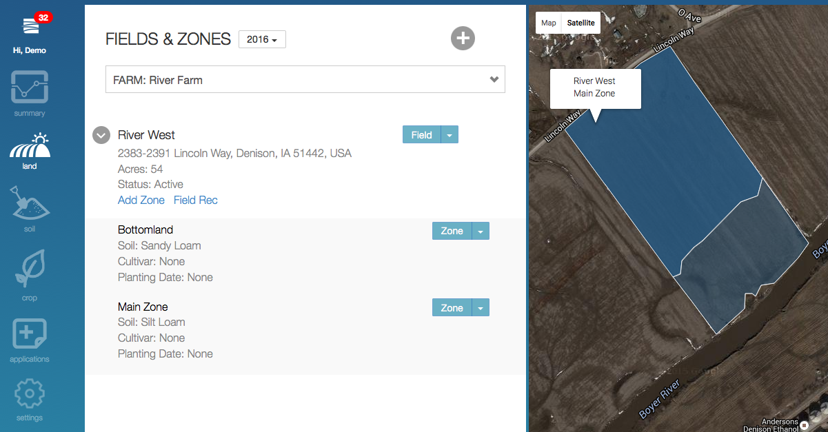
When looking at the Fields & Zones view, VRT Fields have a graph icon next to their name, whereas point-based fields have an arrow next to their name (to expose manually created zones):
Configuring a Variable Rate Field
Click "Configure Field" on the Fields & Zones view, or click the "Configure Field" item in the Field menu, to enter the VRT field configuration interface:
The Variable Rate Field Configuration Interface is then displayed. Similar to point-based fields, users provide information specific to the field and farm management practice. The configuration for each layer of data is accessed by clicking on the layer name. The following layers may be configured in variable rate fashion by importing a Shapefile or by Syncing to a Data Source:
- Soil Type
- Slope
- Soil Organic Matter
- Expected Harvest Population
- Expected Yield
- Nitrogen Applications
Other layers of data, including crop rotation, tillage method, and manure and irrigation applications, are configured in a flat-rate fashion for the entire field. These layers may become variable in the future. If you are syncing a field to the agX Platform, please reference this article instead, as the remainder of this article assumes the field was imported using a Shapefile.
Click a layer's name to expose its data import options. For example, the Soil Organic Matter layer accepts a Shapefile or a Constant Value. Click the data import type (e.g. Shapefile) to expose additional controls, including a way to locate the Shapefile on your computer, input fields for additional required data, and in some cases optional input fields for Default values.
Tips:
- Shapefiles must be submitted in the form of a Zipfile, containing the individual Shapefile components (.shp, .shx, .dbf, .prj).
- For soil type, slope, expected harvest population, and nitrogen applications, the data within the Shapefile should be polygon-based. For soil organic matter, either polygon or point-based data is accepted.
- You may submit multiple columns within a single Shapefile, which you would select within each layer, or you may submit separate Shapefiles each with one column of data. If multiple columns of data exist, you will be prompted to identify the proper column of data for the layer being configured.
Here is a view of an example Shapefile, containing columns as follows:
- AREASYMBOL: represents the FIPS code required by the Soil Type Import (FIPS is a 2-digit state and 3-digit county code).
- MUSYM: represents the MapUnit Symbol required by the Soil Type Import. This corresponds to the SSURGO soil database provided by NRCS.
- Yield: the expected yield value for each polygon within the field, represented in bu/ac.
- SOM: represents the soil organic matter % for each polygon within the field.
- Population: represents the expected harvest population for each polygon within the field.
- PreplantN: represents pounds per acre of nitrogen already applied to the field.
This sample Shapefile is available for download at the bottom of this page.
When submitting the Shapefile to Adapt-N, a dialog box will prompt you to select the appropriate column in your shapefile for the data layer you are submitting:
Any column name is acceptable, as long as it does not start with a number. When the Shapefile has been processed, a confirmation will indicate the area of the field covered; in cases when the Shapefile does not cover the entire field, the optional Default Value will be used.
All layers are required except for Nitrogen Applications, Manure Applications, and Irrigation Applications. You can partially complete a field configuration and return to it later, as each layer is saved individually once submitted.
Running a Variable Rate Recommendation
Once the required layers have been configured, Activate the field (either from the top of the VRT configuration interface or from the Fields & Zones view). To initiate the variable rate recommendation, click Run Active Zones from the Field menu. This launches a background process to run the necessary simulations for that field.
You may continue working elsewhere within Adapt-N, or you may visit the Field Recommendation page to monitor its progress. A notification badge will be displayed in the navigation bar, above your name, when the recommendation is complete (it may take several minutes). Alternatively, you may click on the icon above your name to check on the status of processing and completed recommendations. Click on the field name to access the recommendation:
Or, visit Fields & Zones and click "Field Rec" on the Field menu to access the recommendation page:
When loading a recommendation that is still processing, partial results will be displayed, with the option to reload the page.
Viewing a Variable Rate Field Recommendation
Once configured and activated, the Adapt-N Variable Rate Recommendation runs automatically on a daily basis, taking advantage of updated weather and any changes entered by the user. Additional features of the recommendation include:
- Summary of Field Rec: includes the minimum, average, maximum, and total pounds of N recommended
- Date selector: select from any date back through 2010, in order to re-run the prescription using the actual weather from the start of the selected season to the date specified (all management dates are automatically adjusted for the simulation)
- Interactive map: click on any of the grid cells to see the specific recommendation for that 60' x 60' cell; click view details for full scientific simulation results, including PDF reports and interactive graphs for that cell
- Interactive graph: hover your mouse over bars in histogram or the values in the legend to highlight the grid cells on the map applicable to those recommendation ranges
- Summary of VRT inputs: shows the minimum, average, and maximum values for the variable rate inputs; if applicable, a summary of nitrogen, manure, and irrigation applications is also displayed
- Export Recommendation: choose export format, products, and make rate modifications. View this article for details.
Adapt-N Field Migration
-
Field Migrations
Between growing seasons, Adapt-N field configurations need to be migrated to the next season. This information can be migrated manually starting on September 1st. If the user does not migrate fields manually, all fields will be migrated automatically on January 1st.
What this means:
- Planting date will be set to the same date in the coming season as was set last season, which should be updated when the real planting date is known
- Planting population values will be carried forward
- Yield target values will be carried forward
- Crop rotation will be carried forward
- Soil information will be carried forward, including organic matter and pH values
- Manure applications that are still valid for the current growing season will be carried forward. For example, in the 2023 growing season, this includes manure applications from 2021-01-01 forward (see here for details)
The following information will not be carried forward:- Nitrogen applications
- Irrigation applications
- Observation values for crop emergence and soil nitrate levels
- Cover crop information
Any information that was migrated to the next season can then be updated to reflect management practices for the next season.
To migrate a field to the next growing season, simply click the Migrate to ____ Season button under the desired field in the Fields and Zones page.
Once this action is complete, users will be able to begin configuring that field for the following season. The previous season's configurations can be viewed by returning to the field configuration screen and selecting the previous season from the dropdown.
Required Configuration Inputs
-
Soil Survey Data
When the Sync with a Source option is selected for Soil Type or Slope layers, Adapt-N's internal Soil Survey database is used to configure the field. Specifically, each grid cell in the field will be automatically set with the appropriate values:
- Soil Texture will be specified based on Adapt-N soil regions and databases
- Drainage classification will be set
- Adapt-N's default rooting depth will be set
- The slope % will be set
In cases when the Soil Survey database lacks sufficient information for a part of a field, only then will the user-provided Default Values be used.
In all cases, the system will inform the user the percent of the field which was set automatically vs. by user-provided defaults.
Users always have the option to upload a Shapefile to set these values, instead of using Adapt-N's databases. Soil data will need to include the following columns:
- AREASYMBOL: represents the FIPS code required by the Soil Type Import (FIPS is a 2-digit state and 3-digit county code).
- MUSYM: represents the MapUnit Symbol required by the Soil Type Import. This corresponds to the SSURGO soil database provided by NRCS.
-
Soil Organic Matter
Soil Organic Matter
Adapt-N recommends using a soil organic matter test that was conducted in the last 3 years. Values can be entered as a flat rate for the whole field or can be submitted spatially using grid- or zone-sampled shapefiles or imported through integrations. In all cases, the % organic matter and sample depth are required.
-
Previous Crop
The purpose of providing a previous crop is to provide the model with information about remaining crop residues and their influence on N availability (immobilization in high carbon residue, or additional N in legume residue). If the crop planted in the previous year is not listed as an option under Previous Crop, a crop with a similar growth pattern (planting density, crop residue) should be selected. Please contact support@agronomic.com if you have any questions. Here are a few suggestions about how to generate the most accurate results:
- Small grains, straw harvested: Substitute silage corn for small grains. The reason for this is that, like silage, small grains after straw harvest leave a minimal amount of surface residue, so that little immobilization of nitrogen occurs. The amount of root residue left by densely planted grains is likely similar to more broadly spaced, but larger, corn root residue.
- Small grains, straw left on surface: When following small grains where straw was not harvested (if residue is still fairly thick by corn planting time) use “grain corn” as the previous crop, so that some immobilization of N in residue will be accounted for, although imperfectly.
- Vegetable crops/potatoes: Substitute soybean for vegetable crops/potatoes, but be sure to add the soybean N credit listed on your results page to your Adapt-N recommendation (15 lbs or 25 lbs, depending on location and soil type) for non-legume vegetable crops. Like soybeans, most vegetable crops leave minimal residue, but most do not fix nitrogen.
For Alfalfa, Grass Hay, Mixed Legume Hay, and Sod - a termination date, Legume Percentage, and Termination Method are also required for input. For any other prior crop, it should also be specified whether a forage-sod was planted in the last three years by clicking the checkbox below the dropdown. This will allow the model to account for N dynamics associated with that forage-sod.
-
Planting Population
Adapt-N asks for an approximate planting population to create your nitrogen recommendation. Plant population options are in increments of 1,000 ranging from 15,000 - 40,000 plants/acre.
When Sync with a Source is selected, Adapt-N will display all available datasets containing planting rate information, including some basic statistics about those planting records. The default value is optional, and will only be used in cases when the selected agX data does not cover the entire field. This includes:
- Crop Establishment and Input (CEI) Applications
- Crop Establishment and Input (CEI) Recommendations
-
Expected Yield
Adapt-N is used as a predictive tool in the early growing season, and the expected yield should therefore be based on an achievable yield, not an average yield, based on the real-world field-specific situation. If seasonal growing conditions are good, we recommend to use the highest yield of the past five years. When the growing season around sidedress time already shows suboptimal conditions (late planting, water stress, pest damage, etc.) adjust the yields downward as appropriate.
Additionally, a planting date and maturity class will also be required with expected yield. Maturities are available for Grain Corn, Silage Corn, Sweet Corn, and Popcorn.
A post-season evaluation of Adapt-N should not be based on the achieved final yield of that growing season, as this may have been impacted by late-season processes like drought, weed competition, hail, or pest pressure that are unrelated to crop N uptake and cannot be predicted at sidedress time. This would not be representative of the use of Adapt-N in a real-world scenario, where an N rate recommendation must be made in spring or early summer.
-
Tillage Methods
Adapt-N models the impact of different tillage methods on nitrogen availability. It simulates decomposition of incorporated vs. surface residues, and adjusts temperature and moisture conditions.
There are nine Tillage methods available for use in Adapt-N:
- Conservation tillage: select the approximate % of the previous crop’s residue remaining on the surface after all tillage passes. Conservation tillage leaves at least 25% of the previous crop’s residue on the surface.
- No-Till: no additional input values are needed. This is modeled equivalently to Conservation Tillage with 100% residue.
- Spring Tillage (only): Enter the approximate date of tillage and the approximate depth of tillage.
- Fall Tillage (only): No additional input values are needed.
- Fall and Spring Tillage: No additional input values are needed.
- Strip-Till/Zone-Till (Spring): No additional input values are needed. Adapt-N assumes a residue percentage of 75%.
- Strip-Till/Zone-Till (Fall): No additional input values are needed. Adapt-N assumes a residue percentage of 75%.
- Ridge-Till (Spring): No additional input values are needed. Adapt-N assumes a residue percentage of 50%.
- Vertical Tillage: No additional input vales are needed. Adapt-N assumes a residue percentage of 50%.
Important note: If multiple methods of tillage are used, select the option that most closely reflects the effects on crop residue incorporation.
When specifying Tillage % Residue, only a general estimate of the % residue remaining from the previous year’s crop is needed (the options in Adapt-N are 25, 50, 75, or 100%). For guidance on estimating this value, you can use the percent surface residue values detailed in the following Purdue University fact sheet: https://www.extension.purdue.
edu/extmedia/AY/AY-269-W.pdf.
Additional Configuration Inputs
-
Nitrogen Applications
So that Adapt-N can account for Nitrogen already added to a field (and how much of that N was taken up by the crop vs. lost), it's important to accurately enter each N application into the system.
In addition to entering the information while configuring individual fields, nitrogen applications can be entered across multiple fields by clicking the "Applications" icon from the left navigation bar, or selecting "Nitrogen" using a zone's view menu option.
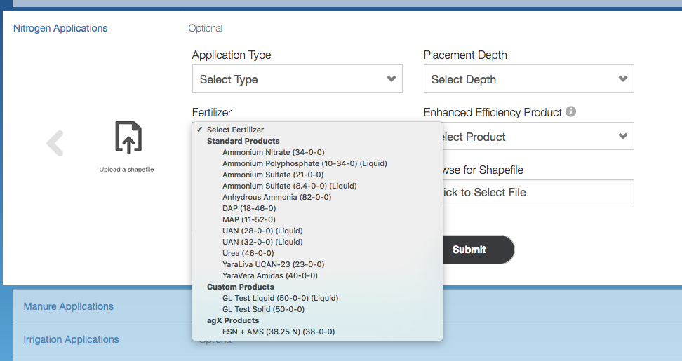
Enter each Nitrogen application, specifying:
- The type of application (Pre-plant, Starter, Pre-Emergence, or Sidedress)
- The date of the application (if Starter, date is not required as the planting date is automatically used)
- The type of fertilizer
- The amount applied and the units for that application (users have the ability to select lbs-N/ac OR gal product/ac if it's a liquid product and lb product/ac if it's a dry product; Adapt-N will convert units of product to units of N, and vice versa, automatically)
- The placement of the application (surface through 10" depth)
- Enhanced Efficiency Products (EEP) used, if any
Adapt-N accepts 1 Nitrogen Application of the type "Starter", to represent N applied at planting. If you have applied more than one type of Nitrogen at planting, you can represent the additional starter applications by adding them as Pre-Emergence applications, specifying the planting date as the Application Date. Adapt-N will treat this in the same way as Starter.
Enhanced Efficiency Products (Stabilizers)
Enhanced Efficiency Products (EEP) options include urease inhibitors, nitrification inhibitors, combined inhibitors, and poly-coated urea. Impacts on N recommendations depend on the effectiveness of the materials, seasonal conditions, management practices, and soil characteristics (esp. organic matter content).
Adapt-N currently incorporates the specifics of the following active ingredients/trade names into its nitrogen recommendations:
Active Ingredient Trade Name NBPT AGROTAIN Duromide + NBPT ANVOL Pronitridine CENTURO DCD -- Poly-coated urea ESN Nitrapyrin N-Serve / Instinct Nutrisphere-N MIC Ammonium/calcium thiosulfates Thio-Sul / CAT Adapt-N's inclusion of, exclusion of, or reference to any trade name is not an endorsement of that product or its manufacturer. Our modeling of these products is based on research associated with the active ingredients in these products.
Additional notes on utilizing EEPs within Adapt-N:
- The use of an EEP must be associated with an appropriate Fertilizer Type in the course of entering a fertilizer application into Adapt-N.
- When using ESN, also select Urea as the Fertilizer Type, as it includes both the fertilizer and control mechanism.
- Adapt-N allows the use of nitrapyrin in conjunction with manure applications. The effectiveness of this practice is not well understood and users are advised to use this feature with caution.
Nitrogen applications can also be submitted by uploading a shapefile. With a shapefile upload, users will have to also select which shapefile field correctly corresponds to the units that was selected previously (lbs or gal of product or lbs of N).
Adapt N will then convert lbs or gallons of product to lbs of N (and vice versa) automatically as shown below.
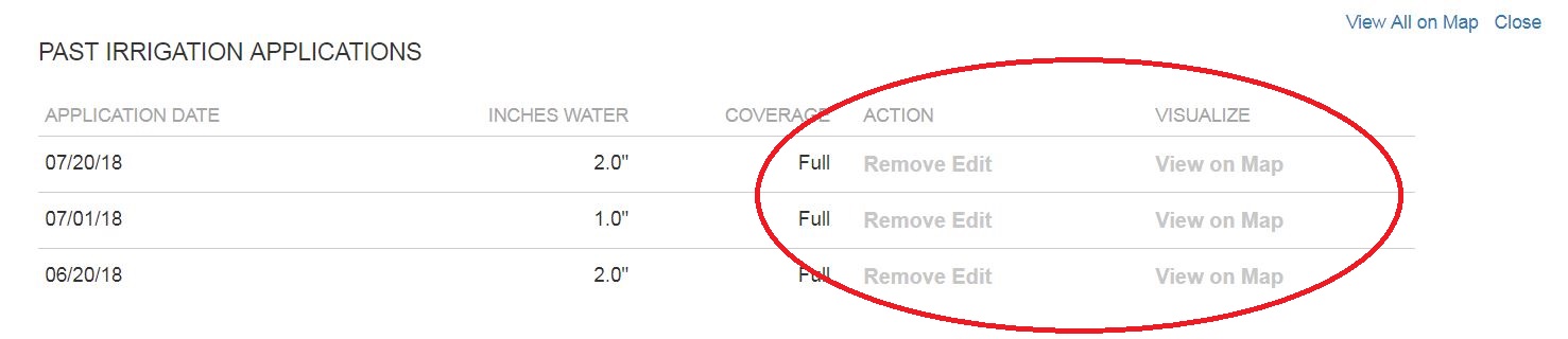
To modify existing Nitrogen applications or view them on the map, click View Past Applications
You can then click Remove, Edit, or View
Applying an Adapt-N Rec Export to a Field
Once an Adapt-N recommendation has been exported as a Shapefile* via the Field Recommendation Export page, a new option becomes available on the Field Configuration screen's Nitrogen Applications layer: "Apply Adapt-N export"
"Apply an Adapt-N export" enables the selection of any past Shapefile* export from this field to be used as a new Nitrogen Application on the field. Fill out the form for application date, type, placement, and Enhanced Efficiency Product, then click to select the desired Adapt-N export file.
If multiple exports exist for the field, preview the information about each selected recommendation to choose the desired export.
The system will automatically perform the necessary product rate conversions and apply the exported recommendation back to the field at the appropriate applications rates across the field. If a custom fertilizer was used during the export, you may be prompted to select the most similar standard fertilizer type during the import. This selection is only necessary for loss and uptake modeling purposes, not for product rate conversion purposes (even with custom fertilizers, the actual N-P-K makeup of the product is appropriately converted to pounds of nitrogen).
A common use for this feature is as follows:
- configure a field in Adapt-N and use it to generate an early sidedress recommendation
- apply that sidedress recommendation in the field
- use this feature to apply that recommendation to the field in Adapt-N on the date it was actually applied in the field
- Adapt-N continues monitoring the field on a daily basis; use N-Alerts or the Dashboards to see if additional N applications may be needed later in the season
* = any export that results in a shapefile being produced is available for use via this feature. This includes Adapt-N's standard shapefile export as well as exports to John Deere Operations Center.
-
Manure Applications
So that Adapt-N can account for additional sources of N (and how much of that N was taken up by the crop vs. lost), it's important to accurately enter each manure application into the system. Historical manure applications can be entered for up to two calendar years in the past. For example, valid manure applications for the 2023 growing season would be any applications made on or after January 1, 2021.
In addition to entering the information while configuring individual fields, manure applications can be entered across multiple fields by clicking the "Applications" icon from the left navigation bar, or selecting "Manure" using a zone's view menu option.
Enter each Manure application, specifying:
- Ammonium N and Organic N
- The date of the application
- Incorporation Method (Incorporated/Injected immediately, within 2 days, within 5 days, or left on surface)
- The rate of application (tons/acre or gallons/acre)
- Percent solids
- Adapt-N allows the use of nitrapyrin in conjunction with manure applications. The effectiveness of this practice is not well understood and users are advised to use this feature with caution.
Manure applications can also be submitted by uploading a shapefile.
In addition to entering the information while configuring individual fields, manure applications can be entered across multiple fields by clicking the "Applications" icon from the left navigation bar or selecting "Manure" using a zone's view menu option.To delete existing manure applications or view them on the map, click View Past Applications
You can then click view, remove, or edit.
-
Irrigation Applications
So that Adapt-N can accurately model the movement of nitrogen in the soil profile, it's important to enter all irrigation events.
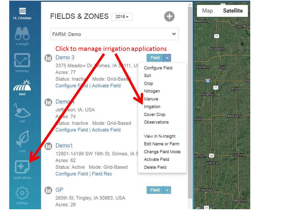
In addition to entering the information while configuring individual fields, irrigation applications can be entered across multiple fields by clicking the "Applications" icon from the left navigation bar, or selecting "Irrigation" using a zone's view menu option.
Enter each irrigation application, specifying:
- Date of application
- Inches applied
Irrigation applications can also be submitted by uploading a shapefile.
To delete or edit existing irrigation applications or view them on the map, click View Past Applications
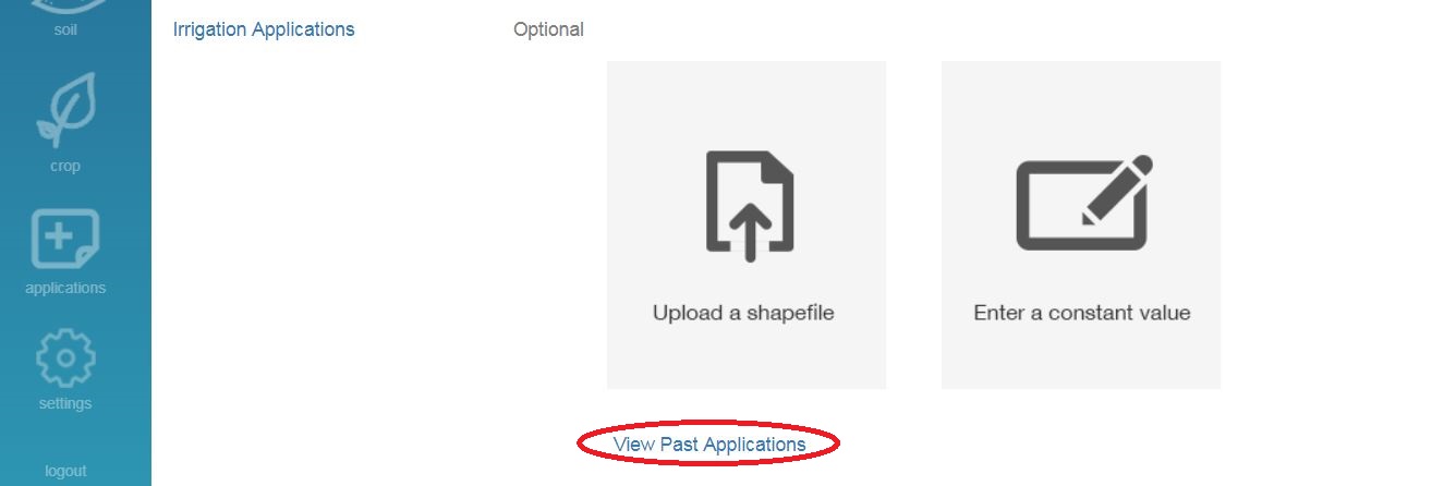
You can then click view on map, remove, or edit.
For more information on more accurately modeling different types of irrigation practices consult our Additional Irrigation Information article.
-
Additional Irrigation Information
For furrow, sprinkler, or drip irrigation, it's important to remember that water can be lost on the way to the pump, or after it has been pumped onto the field. The water can be lost to evaporation, surface runoff, or percolation below the rootzone of your crop.
Determining how much effective irrigation your crop will receive requires making an estimate of the efficiency factor for your irrigation system. The following suggestions are for estimating efficiency between your pump and the field. Start with the range of factors in the table that correspond to your irrigation method. Then consider your local conditions and choose a value in that range. If the weather is especially warm or windy, your efficiency will be lower. If your soil has a loamy texture water infiltrates more slowly and evenly, so your efficiency will be higher than on a sandier soil.
Irrigation methods
Field application efficiency
Furrow (conventional)
45-65%
Furrow (surge)
55-75%
Furrow with tailwater reuse
60-80%
Sprinkler irrigation
65 - 85%
Drip irrigation
90%
The application efficiency along with Rate (gal/min), Area (acre), and Time (hours) can be entered into our Irrigation Calculator (click here to download it in Excel). The calculator will assist you in determining the correct precipitation equivalent to input into Adapt-N as an irrigation event.
-
Cover Crops
Adapt-N models the contribution of terminated cover crops to available nitrogen. This contribution depends on the following inputs:
Cover Crop Type: select grass, legume, or a mix of the two. Mixes are approximated to mostly grass, mostly legume, or an even mix.
Cover Crop Stand: select the best description for cover crop stand at the time of termination. Stand refers to the density of plants, which results from original planting density, crop establishment, and/or winter kill. Sparse stand implies lower plant density with large or numerous thin or bare spots. Medium stand implies medium density, moderate winter kill or thin patches or bare spots. Dense stand implies good establishment with little winter kill.
Cover Crop Stage: the approximate growth stage at which the cover crop was terminated. For mixes, including mixes that are mostly legume, use the growth stage of the grass component.
Cover Crop Incorporation (after termination): select whether the cover crop was left on the surface, partially incorporated, or fully incorporated.
Termination Date: enter the date the cover crop was terminated (surface killed or incorporated). This date must be before any spring tillage event.
It is important to note that when thinking about whether the crop is a Cover Crop or a Prior Crop in the Adapt-N configuration, the general rule of thumb is that if some or all of the crop is removed from the field, it would be considered a Prior Crop. If all the plant matter was left in the field, it is considered a Cover Crop.
Additional info:
http://ulster.cce.cornell.edu/resources/grains-school-2015-2-small-grains-growth-stages-management
-
Rooting Depth
The Rooting Depth parameter for a zone is used to determine whether nitrogen that has moved within the soil profile during the season is still within reach of the crop's roots, or whether it is effectively lost. Adapt-N has developed a database of realistic rooting depth defaults for each combination of soil texture and drainage classification in each county. However, since management practices and field/weather conditions can have a significant impact on rooting depths over time, we recommend users evaluate actual rooting depth in their fields and make adjustments accordingly. Consider taking penetrometer measurements to account for compaction and rootzone limitations. Consider weather influences that may impact rooting depth (e.g., very high rainfall tends to reduce rooting depth).
Evaluating Rooting Depth in a Field
The easiest time to evaluate rooting depth of a fully grown crop is after the season ends. In a few representative locations, dig deep enough so you can easily pull out the root mass without breaking off a lot of roots, or dig a small trench and view them from the side. The rooting depth should be assessed based on the vertical proliferation of a majority of roots, not an incidental root that may have gone deeper than most. We do not recommend relying on rooting depth values from soil survey databases, which tend to be overestimated. The actual rooting depth discovered should then be applied to Adapt-N for the following seasons. In the case of a very wet early growing season, it may be worthwhile to assess whether rooting depths are reduced, especially in fine-textured soils and when drainage is imperfect, and update Adapt-N accordingly.
If you have not had an opportunity to evaluate rooting depth in advance of the season, it can still be evaluated during the season. We recommend digging up roots no earlier than V7.Modifying Rooting Depth Values in Adapt-N
Fields can have their Rooting Depth values modified either as a flat value, or spatially, via the Configure Field interface. If a Shapefile is provided, values should be specified in inches. Else, the "Enter a Constant Value" option enables the entire field to be made more shallow, deeper, or set to a specific value.
When the Rooting Depth panel is open, the legend in the map interface displays the current values across the field.
Deleting Existing Nitrogen/Irrigation/Manure applications
-
Removing Applications
Applications of nitrogen, manure, and irrigation may be applied to parts or all of a VRT Grid field, and either at a constant or a variable rate. To remove an existing VRT Grid field's applications:
- Return to (or reload) the Field Configuration interface
- Open the layer of application type you wish to modify (e.g. Nitrogen Applications)
- Then click the "View Past Applications" link
- You will then be presented with a list of existing applications, with an option to Remove them

Activating Fields
Field Activations and Training Mode
-
Live Field Activations
When activating a field for live recommendations, there may be some cases when the user doesn't want a nitrogen recommendation for the entirety of the field. For example, if only part of the field is planted to corn for the current season. When performing the Live Activation, you can select which part(s) of the field you want to activate. Accordingly, the recommendation will only include those parts of the field, and the account will only be billed for the acreage of the activated parts of the field.
To partially activate a field, use the map control to click on or draw over parts of the field desired for activation. Notes:
- Point-based fields cannot be partially activated.
- Zone-based fields can be activated on a zone-by-zone basis. Note that multi-polygon zones still need to be activated together (you cannot activate just one polygon within a multi-polygon zone).
- Grid-based fields can be activated down to the individual grid cell level.
- The first time a field is Live Activated, the minimum billable field size will be enforced, if applicable.
Example of a partial field activation for a grid-based field (bright green section currently selected for activation):
If the user wanted to subsequently activate the rest of the field, click Activate again. In this example, the rest of the field is selected (shown in bright green) for activation:
-
Training Mode
The Fields & Zones page clearly indicates fields currently in Training Mode. Such fields can subsequently be Activated into billable mode to run in-season recommendations:
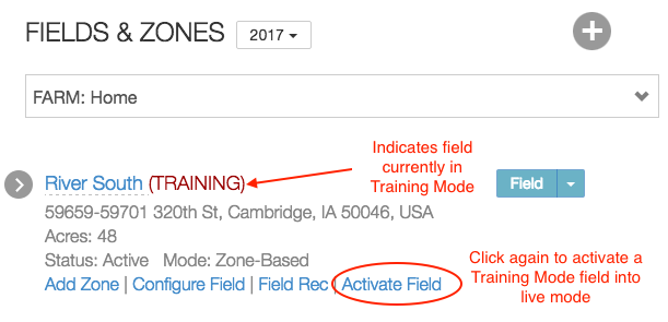
The actual recommendation for a field in Training Mode is available using prior-season weather data only. Training Mode recommendations are not suitable for in-season purposes, as they do not use weather data from the current season. In addition, users are not allowed to export data from Adapt-N fields in training mode.
Click the Activate Field link at any time to move the field into billable mode.
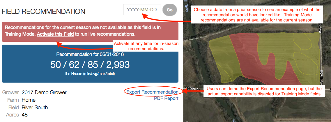
-
Important Notes
Summary Explanation of Field Status
When a field is created, it is in a non-billable state ready for configuration. In order to run a recommendation, the field must be configured and activated. There are two types of activations:
- Training Mode: allows for recommendations using a prior season's weather data. Training Mode field activations are not suitable for use in the field and are only for example and training purposes. As such, alerts and exports are disabled. There is no charge for Training Mode activations.
- Live Activation: enables the recommendation to be run using the current season's weather data. This is for producing a "real" recommendation to be used this season. With Live Activations, you can still choose to run an analysis using a prior year's weather data.
A field can first be activated into Training Mode, and subsequently activated again for live recommendations.
User Permissions
Billing Admins can control what types of activations each user can perform, by visiting Setup -> User and Grower List -> Updated Agronomist User.
Users who have access to both Billable and Training Mode fields will be presented with an option as to which field mode they'd like, after clicking the Activate Field link:
- A user's Field Activation Rights permission only controls what type of a field activations they may perform. It does not restrict their ability to modify field configuration data or run recommendations for a field that may have been Activated into billable mode by another user.
Deleting Fields
-
Deleting Fields
To delete a field, select the "land" option on the navigation bar and choose the appropriate grower and farm. From the Field menu, select the "Delete Field" option:
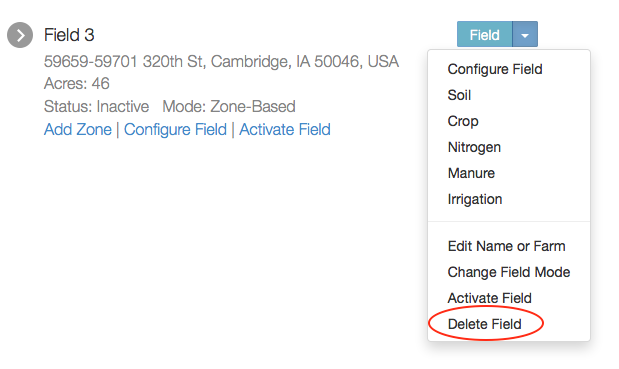
Then confirm the deletion:
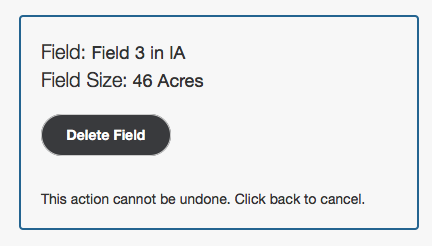
Notes about deleting fields:
- A field may only be deleted if it has not yet been Activated. If you need to delete a field that is already Active, contact support.
- Only users with permission to Activate a field have permission to delete a field.
- At the start of each new season, all fields return to Inactive status.
Nitrogen Recommendations
Daily Nitrogen Recommendations
-
Daily N Rec
Once a field has been fully configured and activated, you can then begin running daily nitrogen recommendations for that field. At the top of the Field Recommendation page, you can manually enter the date of your choosing or click the "Go" button to run a recommendation for the current day. When the rec is finished, you will see the recommendation displayed in a minimum/average/maximum/total/excess format and the recommendation displayed on the map.
From this page, you also have the option to create a multi-year analysis, export the recommendation, or view a PDF report of the recommendation.
-
Zone Recommendation Statistics
The Zone Recommendation Statistics show the minimum, average, and maximum values across all active zones in the field.
-
Zone Recommendation Details
To further understand the nitrogen recommendation and view detailed statistics on each zone in the field you can click any point within the field boundary and click "view details".
The following page will be displayed:
Here you will see a number of details about that specific zone in the field.
Sidedress N Recommendation is calculated by Adapt-N using the following equation:
"Expected N in crop at Harvest" - "N in crop now" - "N in soil now" - "Future Net N credits" - "Partial N credit from soybean" + "Expected future fertilizer loss" - "Profit Factor"
Explanation of Terms
Expected N in crop at harvest is the amount of N estimated to be in the corn crop at harvest time. This is calculated from the "Expected Yield" input combined with the Recommendation Parameter for Pounds of N per Expected Bushel of Yield. Estimates of N contents of grain, stover and roots are used.
N mineralization so far is plant-available N derived from soil organic matter or organic amendments from simulation start date until the current date.
N loss since planting / since simulation start date reflects all nitrogen losses since the beginning of the simulation or since the planting date. This includes all nitrogen lost from manure applications, overwinter leaching losses, lost nitrogen from organic matter mineralization, as well as losses from all types of N applications (ammonia volatilization, etc.).
Additional N Credits includes credits from previous crops as well as from manure applications. This is supplemental to the simulated effects of N mineralization or immobilization from incorporation of previous-crop residues.
N in crop now is the amount of N that is already in the crop for the day you run the model (or on the season end date you selected if you are running on a prior season). This is determined by simulations using the corn growth routines in the model, and incorporates information from the high resolution weather data and soil N availability for the field location.
Expected Future Fertilizer Loss represents the N loss risk specifically for the recommended fertilizer application. This basically is a time-dependent fertilizer use efficiency factor. Values represent the fraction of the fertilizer to be applied that can be expected to be lost due to weather events following application, based on probabilistic estimates from 30 year simulations. Values are proportional to the recommended fertilizer rate, and they will generally decrease as the growing season progresses and the risk of N losses from weather events is reduced
Future Net N Credits represents the combined nitrogen credits and debits that are expected for the remainder of the growing season. Credits include future mineralization from soil organic matter, manure applications, previous crop, etc. They are generally higher with soils with high organic matter contents and when organic amendments have been applied. Debits include the risks associated with future leaching and denitrification losses, which are mostly based on current nitrate levels in the soil, potential future mineralized N, and the time in the growing season. In general, debits from future losses are greater for simulations done in early spring, as the N loss risk from high rainfall events in the following weeks is higher. Also, debits are higher for cases where high N rates have been applied prior to planting, as this generates greater potential for early-season losses. As the growing season progresses and weather events are playing out, the recommendations become more precise and the N loss risk is reduced. Values are probabilistic and based on 30 year simulations.
N in soil now is the amount of mineral N available to the crop from the soil for the day you run the model. This is determined from model simulations based on input information on soil type, rooting depth, slope, organic matter content, tillage system, previous organic and inorganic N applications, rotations (sod, soybean, etc.), and corn variety, maturity class, and population, where mineralization and losses are similarly affected by weather to date.
Rainfall since planting / since simulation start date reflects climate data which is updated several times per day. (estimates may slightly change in following 2 days as more precise precipitation data become available).
Current plant available water / Maximum plant available water represents the plant available water for today's soil moisture status for that soil texture. The Maximum plant available water is what is available when at field capacity.
Current Nitrate / Virtual PSNT represents simulated nitrate levels in the top 12” and 12"-24" depth of the soil on a daily basis throughout the season. The virtual PSNT is presented as a convenient comparison but is not used directly to make a recommendation. Our field trial data show the virtual PSNT simulated by Adapt-N to generally be within 5 ppm of the measured value. See this article for further details and recommended sampling protocol.
Current Ammonium N represents simulated ammonium N levels in the top 12" and 12"-24" depth of soil on a daily basis throughout the season.
Other
Profit Factor is a correction factor to optimize profits to N application from the combined effects of the fertilizer-to-grain price ratio and the uncertainty of Adapt-N predictions. The price ratio correction accounts for the cost of fertilizer relative to the returns from additional yield with higher N inputs. This results in lower recommended N rates with more expensive fertilizer or lower corn grain prices. The uncertainty correction accounts for the fact that nonlinear yield response to N inputs entails a greater profit penalty (risk) for under-prediction than over-prediction of the optimum N rate, and therefore the need for an adjustment of the recommended N rate. In all, the Profit Factor is adjusted based on (i) the price of fertilizer, (ii) the price of corn (grain, silage, or sweet), and (iii) the primary N source (manure or fertilizer). View this article for information on how to modify these parameters.
The Sidedress N Recommendation is therefore the difference between net N availability (a function of N inputs, weather-affected mineral N gains and losses, and management) and the final expected N content of the crop. This difference needs to be made up by sidedressing to achieve full yield. The Adapt-N model does not include estimates of atmospheric N deposition as it makes a very minor contribution to corn N needs.
-
Nitrogen Graphs
For more insights to how your nitrogen recommendation has been determined, click on the Graphs link below the map in the recommendation details screen.
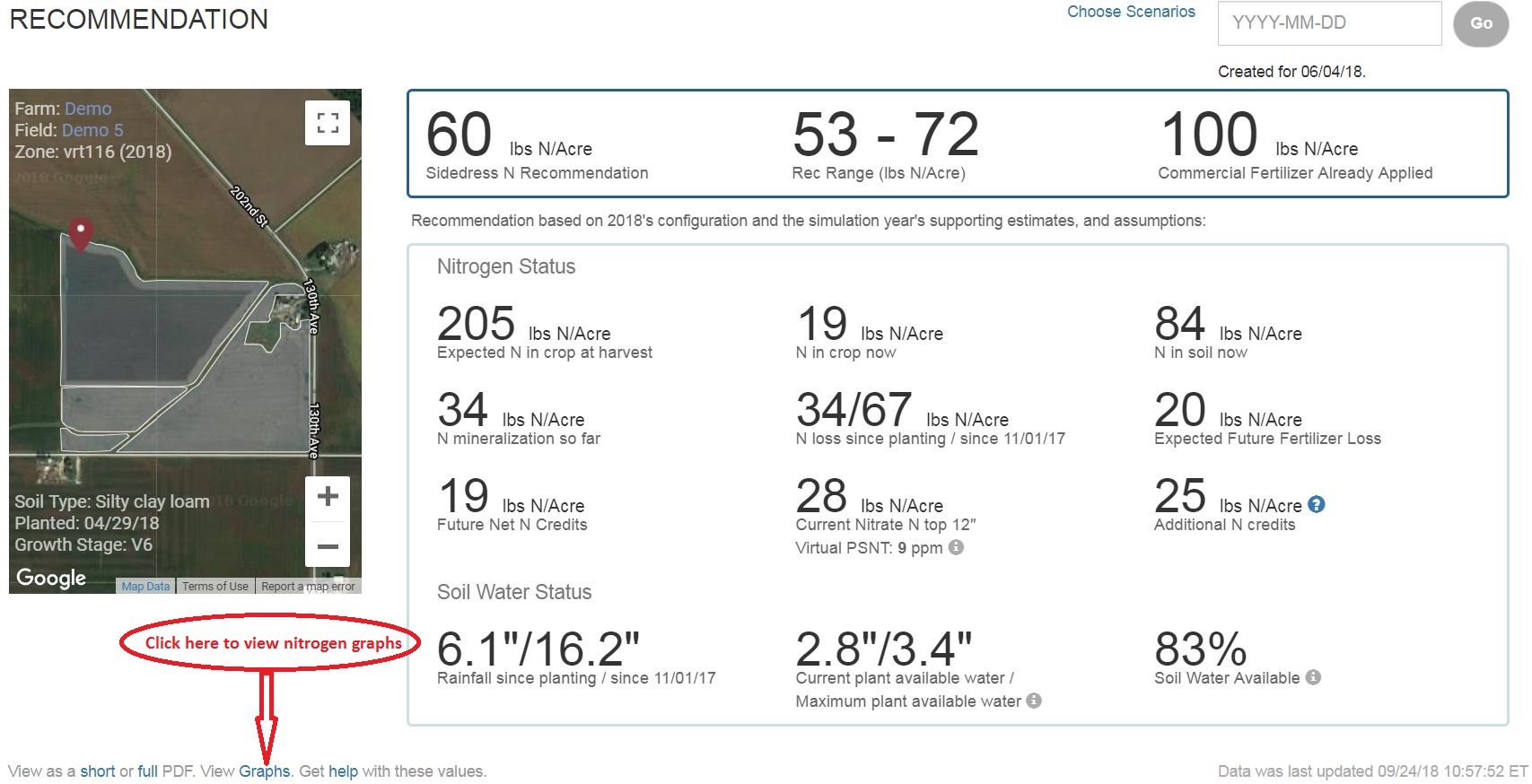
Here you can view how nitrogen losses, uptake, and mineralization have been affected by whether patterns throughout the season.
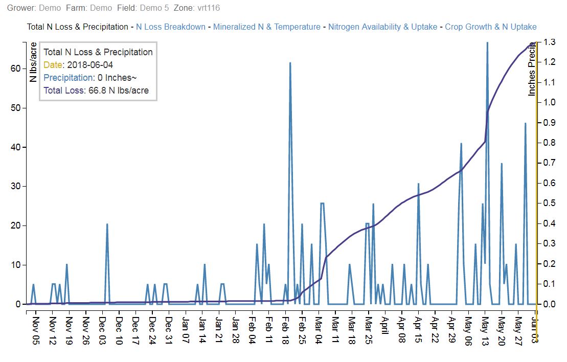
-
Multi-Year Analysis
A multi-year nitrogen recommendation analysis can be a powerful tool in understanding how specific nitrogen management practices have performed historically under different actual weather conditions of a field.
After configuring, activating, and running a recommendation, you have the ability to run a multi-year analysis with the current field configuration for the same date from any set of seasons since 2010. Click Create Multi-Year Analysis in the field recommendation page to begin.
You will then need to select a simulation date and which previous years you would like to run in the analysis. This analysis is available in both training mode and live, billable mode. In training mode activations, the current year will not be available. In all cases when including the current year, simulation dates only through "yesterday" are available.
The multi-year analysis will then use your current field configuration to compare the recommendation for the most recent season selection (only as recent as the previous season if generated in training mode) to the other selected growing seasons. The analysis will include the N recommendation, N loss, N mineralization, and rainfall totals for each season. This allows you to more accurately evaluate the current nitrogen management for that field and understand why recommendations change from year to year.
In this example, we see an analysis for June 1st. This field received 100 lbs of fall anhydrous ammonia. On June 1, 2018 Adapt-N called for an average of 67 lbs of additional nitrogen for a total of 10,363 lbs of additional N across the field. As of June 1st, the field had received 9.7" of rainfall contributing to an average of 27 lbs of N loss. There was also an average of 22 lbs of N mineralized.
For comparison, on June 1, 2012 Adapt-N called for an average of 53 lbs of additional nitrogen for a total of 8,155 lbs of additional N across the field. A 21% decrease compared to the recommendation for 2018.
However, on June 1, 2016 there was a 147% increase in the amount of additional N needed compared to 2018. Taking a look at the total rainfall of 25.3", you can see there was a substantial increase in the amount of rainfall compared to the 9.7" in 2018. These wet conditions contributed to an average of 126 lbs of N loss.
In this example, the 100 lbs of anhydrous ammonia in the fall worked okay for the grower in 2018 and 2012 but resulted in substantial nitrogen losses in 2016. Using this analysis helps illustrate how an adaptive nitrogen approach could pay dividends for this grower by planning for and reacting to changing weather conditions in their field as the season progresses.
Exporting Recommendations
-
Field Recommendation Export
VRT recommendations can be exported as Shapefiles or in some cases back to source systems, such as the agX Platform. From the Field Recommendation page, click Export Recommendation.
- When multiple formats or destinations are available, an "Export Type" option will be displayed. Otherwise, the export will be as a Shapefile.
- Optionally specify one or more nitrogen products. Selected products will be converted to the appropriate units in the recommendation. Optionally choose a rounding option, which will round the product rate to the nearest rounding value.
- Optionally, indicate a maximum application rate for a given nitrogen product, by selecting the "Cap Rate" option in the Percentage box. You will then be given the opportunity to specify the product application rate (e.g. gallons/acre for a liquid product, pounds/acre for a non-liquid product) that should not be exceeded. If you specify a "Remaining Nitrogen Product," that product will be utilized for parts of the field in which the Adapt-N N rec has exceeded the Cap Rate value specified for the Primary Nitrogen Product.
- Optionally modify the rates for the exported recommendation, either by modifying the entire recommendation (setting minimum/maximum or adjusting by percentage or fixed amount), or by manually adjusting individual rates.
Example 1
In the above example, the custom fertilizer called "Sidedress" will be applied but only up to a maximum application rate of 5 gallons/acre. Parts of the field which are calling for more than the nitrogen supplied by that application rate will also include a product rate for the standard UAN 28% product, specified as the Remaining Nitrogen Product. The downloaded shapefile will be named "Sidedress_rec.zip".
Example 2
In the above example:
- UAN (28-0-0) was selected, with the product rate to be rounded to the nearest 5 gal/acre value
- A minimum value of 30 pounds N per acre was set
- The rate originally at 50 pounds N per acre was manually lowered to 30
- The rates originally at 95 and 120 pounds N per acre were raised to 125 pounds N per acre
Below is the resulting Shapefile based on the above export parameters:
- In the below example, a single zone is highlighted, for which the N rate is 125 lbs N per acre and the product rate is 40 gallons/acre.
- Users have the ability to manage which columns they want to appear in exported shapefiles, Pounds of N (z100_0_0) and Product Rate (zN_P_K) by checking the box of the columns you would like.
- Whenever one or more products are selected, a pair of additional columns will be included for each product: z28_0_0 represents the UAN 28% rate, and uz28_0_0 represents the units for that product.
Example 3
If two N products are selected, and both product rates are of the same unit (e.g. gallons/acre), then the resulting shapefile will contain individual product rates, as well as a TotalProd column, which contains the combined rate of a pre-blended fertilizer:
Summary PDF
All Shapefile exports also include a Summary PDF in the resulting zip file, which indicates the total amount of product required to fulfill the recommendation as modified.
-
Bulk Field Recommendation Export
Users also have the ability to export multiple fields by switching to the Multi-Field Export Tool.
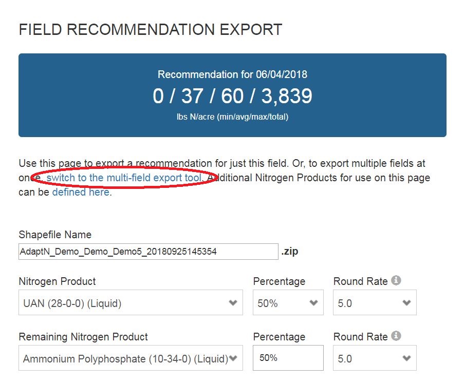
Within the Multi-Field Export Tool you can select whether you want to execute a bulk shapefile export or bulk PDF report export. Product and rates can then be designated.
On the right-hand side, check the box of the fields you wish to export.
Note: Only fields activated for the current season are shown and only fields with recent recommendations are available for export.
N-Insight
N-Insight
-
N-Insight Setup
Creating N-Insight Reports
Select the "N-Insight" icon from the left navigation bar and click the + button to create a new field or select a grower and field from the dropdown to run N-Insight on a field that has already been created. Once a field has been created or selected from the dropdown, some general information about the current management of the field will need to be provided.
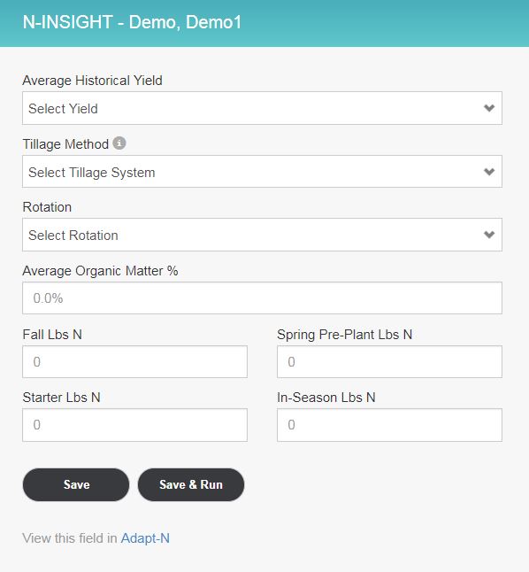
Planting dates for the previous five growing season can also be entered under them map.
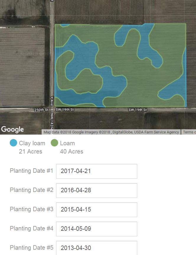
Once the information is entered, click the "Save & Run" button and the report will be processed. When finished, click the "Report" link on the right to view the N-Insight report.
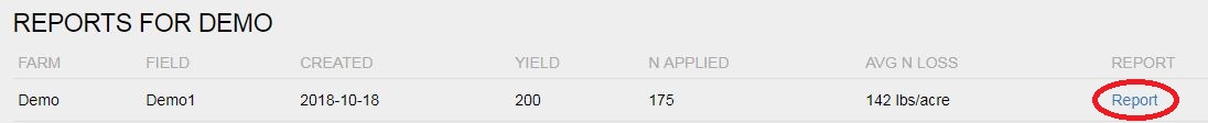
After clicking the "Report" link, the N-Insight report will be displayed and users will have the option to view the report as a PDF or enroll the field in Adapt-N by clicking the appropriate link.
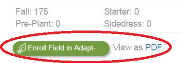
-
Understanding N-Insight Report
N-Insight is a great way to show the year-to-year variability of zones and how efficiently those zones use nitrogen. The N-Insight Report shown below was ran using an N rate of 175 lbs applied in the fall.
Near the top of the report written in pink, you can see that the average per acre loss of total N was 142 lbs for the 5 year scenario. It's important to understand that this is TOTAL N (losses from both commercially applied fertilizer as well as mineralized nitrogen) and not just applied N. Below this you can see the average applied N loss of 105 lbs or 59% of applied N.
The report also shows you a map of the different soil texture zones in the field and a bar graph showing N losses in each zone during each year.
In this example, 2013 had the highest nitrogen losses with the current management practices used on this field with 71% of applied N being lost. Both the clay loam (blue) and loam (green) zones in this field were deficient of N which is signified by the ear of corn in each zones bar in the graph. This resulted in a weighted average total N loss of 166 lbs in 2013.
For comparison, 2015 had lower nitrogen losses with 45% of applied N being lost. However, in 2015 the loam zone had a surplus of N which is signified by the "N" in the green bar while the clay loam zone was deficient of N (ear of corn in the blue bar). This resulted in a weighted average total N loss of 106 lbs in 2015.
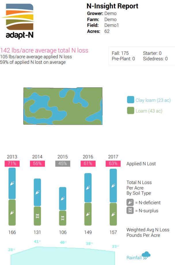
Archived FAQs
FAQ's
-
Nitrate Sampling Protocol and Recommendations
Soil Nitrate Test Observation
Adapt-N’s Virtual PSNT (sometimes called LSNT) provides simulated nitrate levels in the top 12” of the soil on a daily basis throughout the season. This helps reduce or even eliminate the need for extensive PSNT sampling.
Users who nevertheless are sampling for soil nitrate levels in the field to enhance the Adapt-N simulations can enter those test results as an Observation into Adapt-N. This adjusts the soil nitrate levels for the date of the test, and subsequently adjusts Adapt-N’s simulations. Explicit nitrate PPM values can be utilized, which cause Adapt-N's nitrate value as of the date and depth of the test to be changed to the user-supplied value, with subsequent daily simulations continuing from that point forward. Or, relative values can be supplied using the Nitrate Adjustment factor. The Nitrate Adjustment factor allows the user to supply a relative percentage by which Adapt-N's inherent nitrate PPM calculations as of a given date and depth will be modified. These observations can be supplied either at the zone level, or via the Field Configuration tool.
Example single-zone observation setting an explicit nitrate value to 10 ppm:
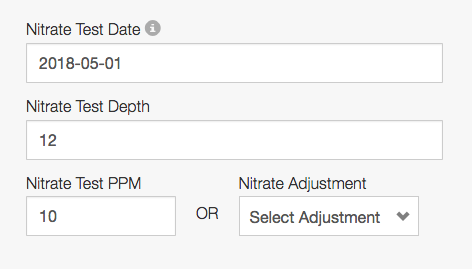
Example single-zone observation using a Nitrate Adjustment Factor to increase the zone's nitrate value by 15% as of the date and depth supplied:
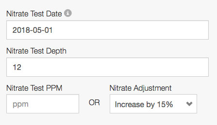
In the above example, if Adapt-N's inherent nitrate simulation on 2018-05-01 was 10 ppm, this would cause the nitrate value to be raised to 15ppm. 15ppm would then be the new baseline moving forward, for future-date simulations.
Recommended Sampling Methodology
Soil nitrate tests are inherently variable, so it’s important to follow guidelines to minimize sampling bias and to maximize the consistency of results. Sampling strategies should be well thought out, documented, and consistently used. Give consideration to the management practices to ensure the sampling effort accurately captures variability within the field.
- PSNT samples should be taken when the corn plants are between 6 and 12 inches tall.
- Weather - make sure necessary precautions or adjustments are made if sampling around rainfall events. Significant rainfall prior to sampling can cause spatial variability in results. This can inaccurately depict losses of applied N fertilizer resulting in excess N being applied. Try to avoid sampling while the field is very wet or within 3 days of a high rainfall event.
- Sample the top 12 inches of the soil profile (the standard depth for PSNT). With early season rainfall events, N below the 1 ft level could very well be lost before the roots reach it.
- Samples should be from representative areas within a field: take management zones, soil textures, or other forms of spatial variation into account when determining where to sample. If possible, log GPS coordinates of sampling locations for future reference.
- Each sample should be based on a composite of multiple soil cores. Collect at least 10 cores per sample to represent a sampling area: Establish a consistent protocol to determine how many cores need to be included in a sample, and where those cores should come from. Balance the cores among row and between-row areas.
- Applications of banded (vs. broadcast) fertilizer or manure applications cause high spatial variability of soil nitrogen -- especially when applied in high amounts (e.g., through a large pre-plant injection). It is very difficult to get accurate PSNT estimates, because the results are highly dependent on whether soil cores were collected from the band or not. A consistent sampling protocol is needed to avoid introducing bias. We suggest the protocol available on this help page to address this challenge. An alternative approach is provided by N Watch https://nwatchonline.com/protocols.
- Handling & Shipping Samples: Talk to your soil lab for instructions on how to handle and ship samples as your lab may have a specific protocol to follow to ensure accurate results. Samples should be sent off as soon as possible after sampling.
- Interpretation of Soil Analysis: We found that Adapt-N’s Virtual PSNT tool does a good job at estimating real field values. But due to the expected high variability of PSNT sample results -- especially with manure and large banded fertilizer applications -- you may see some discrepancies between the measured values and Adapt-N’s virtual PSNT estimates. Our field trail data has shown Adapt-N to generally be within 5 ppm of the measured value.
- Once you interpreted the results, you will need to be confident of their accuracy before implementing them into your N strategy. Adapt-N takes these results at face value and makes no determination on their accuracy. If you have concerns over sampling analysis, talk to your soil lab before utilizing results.

Source: N-Watch
Release Notes and Updates
2020
-
Spring 2020 Model Update
Adapt-N uses a mass-balance equation to derive a final N recommendation, which includes the final crop N needs to achieve the expected yield, soil N availability, current crop N status, future N credits, and potential loss and risk factors. In this approach there is a linear relationship between the expected yield and the amount of recommended nitrogen: higher yields require equivalently more N. Recent research has demonstrated that this relationship is not linear with fields that have low yield potential. The underlying causes - compaction, drainage, water deficits, etc. - also affect the crop’s ability to take up the available nitrogen, which results in lower nitrogen use efficiency. Based on results from many field trials, Adapt-N has implemented an improved methodology to account for decreased N use efficiency in cases where yields are below-normal for a region. Adapt-N already recommends lower nitrogen for fields with lower expected yields; it now also accounts for the reduced nitrogen use efficiency in those low yielding fields, having an effect of slightly increasing recommendations in such cases.
2017
-
Planting 2017 Release Notes
Welcome back to Adapt-N for the 2017 Season! This post contains highlights of key updates to the system. Don’t hesitate to reach out to support@adapt-n.com with any questions.
New training videos available
When you first log in, you’ll see a set of updated training videos, appropriate for both new and experienced users. Consider taking a few minutes to see recorded demonstrations of Adapt-N, showcasing many of these new features.
Field Rec Export Tool Enhancements
The Field Recommendation Export tool has a new feature which lets you select a maximum application rate for the primary nitrogen product. If a second nitrogen product is selected, the remainder of the full N rec for a given part of the field will be allocated to that product automatically. A good example is if you want to apply a maximum of 5 gal/ac of a custom product, but parts of your field call for more Nitrogen than would be provided by 5 gallons. This configuration would accomplish that objective:
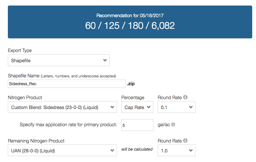
Three other updates have also been made to this tool:
- When choosing a Shapefile as the export type, you can customize the name of the exported file.
- The percentage for the Remaining Nitrogen Product now automatically adjusts if you select a percentage below 100% for the primary Nitrogen Product.
- The PDF included with the exported Shapefile now has map colors that correspond with the adjusted recommendation, as opposed to the original recommendation.
Change Field Mode Tool Supports All Options
When looking at the Fields & Zones view, click the Field menu and select Change Field Mode if you’d like to adjust or reset the zone management approach to an existing field. This tool has been updated to provide the full suite of configuration options that exist when creating a field from scratch. This includes all three field modes (point-based, zone-based, grid-based), as well as all zone creation options:
- None: you’ll draw your zones by hand.
- Single Zone: create one zone for the whole field.
- By Soil Type: use the soil survey database to create zones.
- Shapefile: select a shapefile for use in creating management zones (you can also choose an attribute from the shapefile for zone names, and can optionally choose whether to combine management zones of identical names).
- Management Zones: if the field is connected to an external system and Management Zones exist in that system, this button will show up. When pressed, a list of Available Management Zones will be displayed.
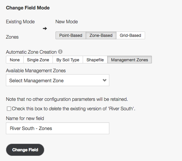
Note that when using the Change Field Mode tool, the new field needs to be fully configured (configuration data other than Boundary do not carry over from the source field, as differences in zone geometry result in different spatial interpretations of source configuration data).
Variable Rate Manure Application Support
Users applying manure at variable rates throughout the field, or users who utilize more than one source of manure on a given field, can now upload Shapefiles via the Field Config tool. This feature functions in a similar fashion to the existing support for variable rate existing nitrogen applications and variable rate irrigation applications.
Zone Stats on Field Recommendation Page
Users looking at a field recommendation can now see a summary of various zone recommendation statistics, including N Loss, Mineralization, Uptake, Virtual PSNT, and more. These show the min, average, and max values for the same output parameters shown on the individual zone recommendation detail pages.
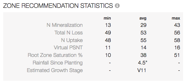
New Integration Available:

Adapt-N has released an initial integration with the John Deere Operations Center. Please contact support@adapt-n.com if you would like it enabled on your account. The integration lets users import field boundaries from John Deere Operations Center, and subsequently transmit completed Adapt-N recommendations back to John Deere Operations Center’s File page. Users who have authenticated with the John Deere Operations Center will be able to upload Adapt-N recommendations to Operations Center from any field, not just those originally imported from John Deere. Future enhancements are planned.
Integration Updates


Field import methods across agX and Agrian integrations have been standardized, so that the same options exist for single- and bulk-field import options. These enhancements include:
- User preferences enabling the automatic syncing of soil survey, soil organic matter, and soil pH data (when available) at the time of field creation.
- Ability to fully configure fields (grid-based fields included) while importing multiple fields at once with the Bulk Import tab. This is a great way to get your fields ready to go, then come back and tweak them individually as needed.
Integration Updates

EFC Systems' FieldAlytics product has completed a full integration with the Adapt-N API. This enables FieldAlytics users to create powerful variable rate Adapt-N recommendations without ever leaving their native interface. Contact EFC Sytems support for additional questions.
Agronomic Modeling Enhancements
The Adapt-N research team continually makes optimizations and improvements to the underlying scientific modeling based on research efforts, strip trial results, and observations from users. Highlights of this year’s enhancements include:
- Addition of Soil pH as an optional configuration input.
- Improvements to the way mineralization is simulated in very high organic matter soils.
- Addition of Previous Crop options for Wheat.
- Addition of an "Additional N Credits" value on recommendations, showing the explicit outputs from manure and previous crops.
Recap of Previous Updates
If you missed some of our previous updates, here are highlights of some of our more popular enhancements from 2016:
- Training Mode enables users to run prior-season recommendations at no charge.
- Crop Emergence and Soil Nitrate Observations can be entered to improve calibration of the model.
- Modifying Recommendation Parameters enable local conditions to be used for for crop prices, nitrogen costs, and pounds of N needed per expected bushel of yield.
- Adjusting Rooting Depth based on field observations improves the accuracy of modeled N losses during the season.
- Read the full release notes from January 2017
-
January 2017 Release Notes
Welcome back to the 2017 season! Over the last few months we've released a number of improvements and new features to Adapt-N, based on user feedback, suggestions, and agronomic research. If you have questions about any of these release notes, please email support@agronomic.com.
N-Insight
N-Insight is now available for all customers. Access the tool via the N-Insight logo, located in the left navigation bar; it is accessible to Billing Admin and Agronomist Users. A PDF report has also been added, accessible from any completed N-Insight report. Billing Admins who wish to customize the timing, form, and placement of nitrogen applications within N-Insight should contact support, as these parameters can be set for all N-Insight fields in an account.
Training Mode Feature
Training Mode is a new feature that lets users run example recommendations using prior-year weather data at no charge, for the purposes of training new users and demonstrating Adapt-N to growers. All Billing Admins have this feature turned on by default, and they can choose to subsequently enable it for other users in their account. Click here for full details.
Nitrogen Recommendation Updates
- The Field Recommendation Page now includes a new set of statistics, summarizing a number of modeling outputs for the field's zones:
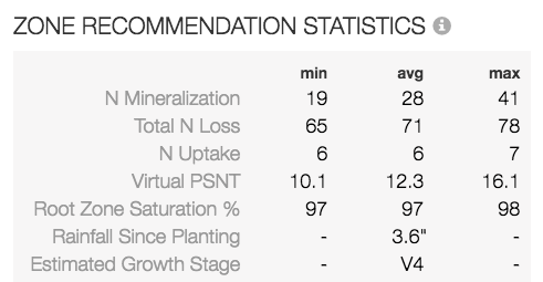
- The Export Recommendation application now lets users modify the names of a shapefile prior to completing the export. Additionally, Foliar products are now supported as a special type of Custom Fertilizer; contact support to set these up. See full details here.
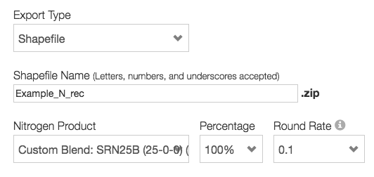
- When viewing a Zone's Recommendation Details (accessed by clicking on a zone from the Field Recommendation map), a Yield Scenarios option is available at the top, next to the date selector. This lets users generate a side-by-side comparison nitrogen recommendation for that zone, under 3 different expected yield scenarios. A PDF export option is also available for this tool.
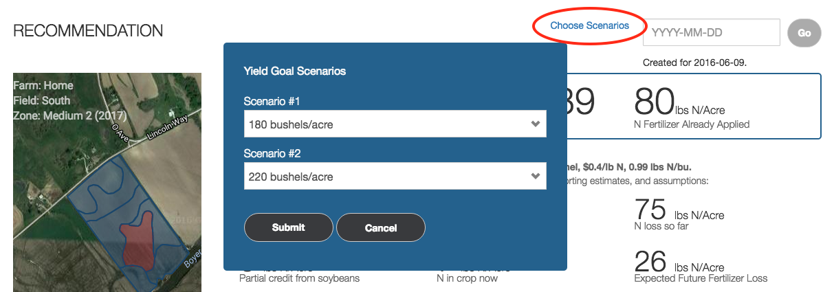
Modeling Enhancements
- Optional Observational values are now accepted by Adapt-N, and are utilized to improve calibration of the models. Specifically:
- Crop emergence date can be provided to re-calibrate Adapt-N's growth model as of the date of the observation
- Soil nitrate test results can be provided, either on a flat or spatial basis, to cause Adapt-N's soil nitrate values to be re-calibrated as of the date and depth of the lab test. Users who have performed side-by-side testing of Adapt-N's Virtual PSNT and traditional lab nitrate tests have found strong correlation. However, deviations can be used as a trigger to review field inputs for accuracy, or observational values can be loaded into Adapt-N to cause a modest adjustment. Please note that research shows that in-field soil nitrate tests are inherently variable.
- Users can now control the pounds of Nitrogen needed per expected bushel of yield. This directly impacts the "expected N in crop at harvest" value seen on the recommendation detail page, which is otherwise calculated based on expected yield. Adapt-N accepts values from 0.9 to 1.2. In the absence of an explicit value being set, Adapt-N's system defaults will be used. Click here for additional details.
- Adapt-N utilizes a set of economic parameters in calculating a risk/profit adjustment that impacts the final recommendation. We've now provided the ability for users to adjust two of these parameters: Price of grain per bushel, and Cost of nitrogen per pound. Click here for additional details. Feature summary;
- Billing Admins can set these values for their entire account, and optionally can also set them for a specific Grower.
- When set, recommendation pages will clearly show which parameters were used. In the absence of these values being set, Adapt-N system defaults will be used.
- In the past, the start date of an Adapt-N simulation was adjusted based on various parameters of the field. This created some inconsistencies in how nitrogen losses would be accumulated in cases when unusual weather patterns were observed at the very end of a calendar year and when the field's parameters would not cause the simulation to start until January 1st. After completing an extensive research effort on this topic, we have modified Adapt-N such that all simulations will begin on November 1st, unless a nitrogen or manure application for the current season occurred prior to that date, in which case the simulation will begin on that date. In most cases, this change will have only a trivial impact on the recommendation. However, in cases where there were excessive rains and/or warm conditions in November and December, this change will ensure that those weather events are properly captured.
- As we've done for years between seasons, we've updated various parameters in our soil, crop, and climate models to optimize performance based on recent lab and field trial data.
Integration Update
- agX Platform / SST Software updates:
- Two new user preferences are now available on the Account tab of the agX Settings page:
- Set soil texture and slope based on Soil Survey information.
- Always attempt to sync Soil Organic Matter values from agX.
- Depending on the user preferences set above, when fields are imported Adapt-N will automatically set soil texture and slope, and will automatically pull the most recent soil test result from agX (must be within the last 5 seasons). Users can subsequently override these values through the normal configuration methods.
- Agrian updates:
- Saved management zones from Agrian can now be utilized for zone creation in Adapt-N at the time of field creation.
- A bulk import tool has been added, letting users import multiple fields at once.
- Two new user preferences are now available on the Account tab of the Agrian Settings page:
- Set soil texture and slope based on Soil Survey information.
- Always attempt to sync Soil Organic Matter values from Agrian.
- Depending on the user preferences set above, when fields are imported Adapt-N will automatically set soil texture and slope, and will automatically pull the most recent soil test result from Agrian (must be within the last 5 seasons). Users can subsequently override these values through the normal configuration methods.
- EFC Systems / FieldAlytics updates:
- Users can now access Adapt-N features directly from within FieldAlytics interface. This includes the ability to enroll fields, configure spatial layers, and run Adapt-N recommendations. Users should work entirely from within the FieldAlytics system and do not need to login to Adapt-N for these features.
- N-Insight will also soon be added to the FieldAlytics system.
- Contact EFC Systems support for further assistance on this integration.
2016
-
Planting 2016 Release Notes
The Configure Field tool is now available for all zone- and grid-based fields
To access, click Configure Field from the Fields & Zones page, either near the field name or from the Field menu. This tool lets users configure the entirety of the field on a layer-by-layer basis, incorporating spatial variability when desired, either by uploading a Shapefile, syncing with a source (such as agX or Agrian), or by manually entering data. The tool has also been updated to show a visualization of each layer. When each layer panel is open, the map at the top will show the current configuration of the field, and will update in real-time based on any changes made by the user.
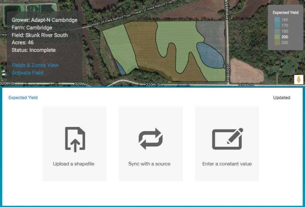
Field Recommendation Export tool upgraded
The tool for exporting a completed recommendation has been completely redone, providing much more flexibility in adjusting rates or setting rounding parameters for each Nitrogen product. Users can now:
- Round the rate for each selected product
- Raise or lower the entire recommendation by a percent or fixed amount
- Adjust each individual rate
- Dynamically view changes to the summary of the recommendation based on the changes
- View a PDF Summary report, automatically included with exported Shapefiles
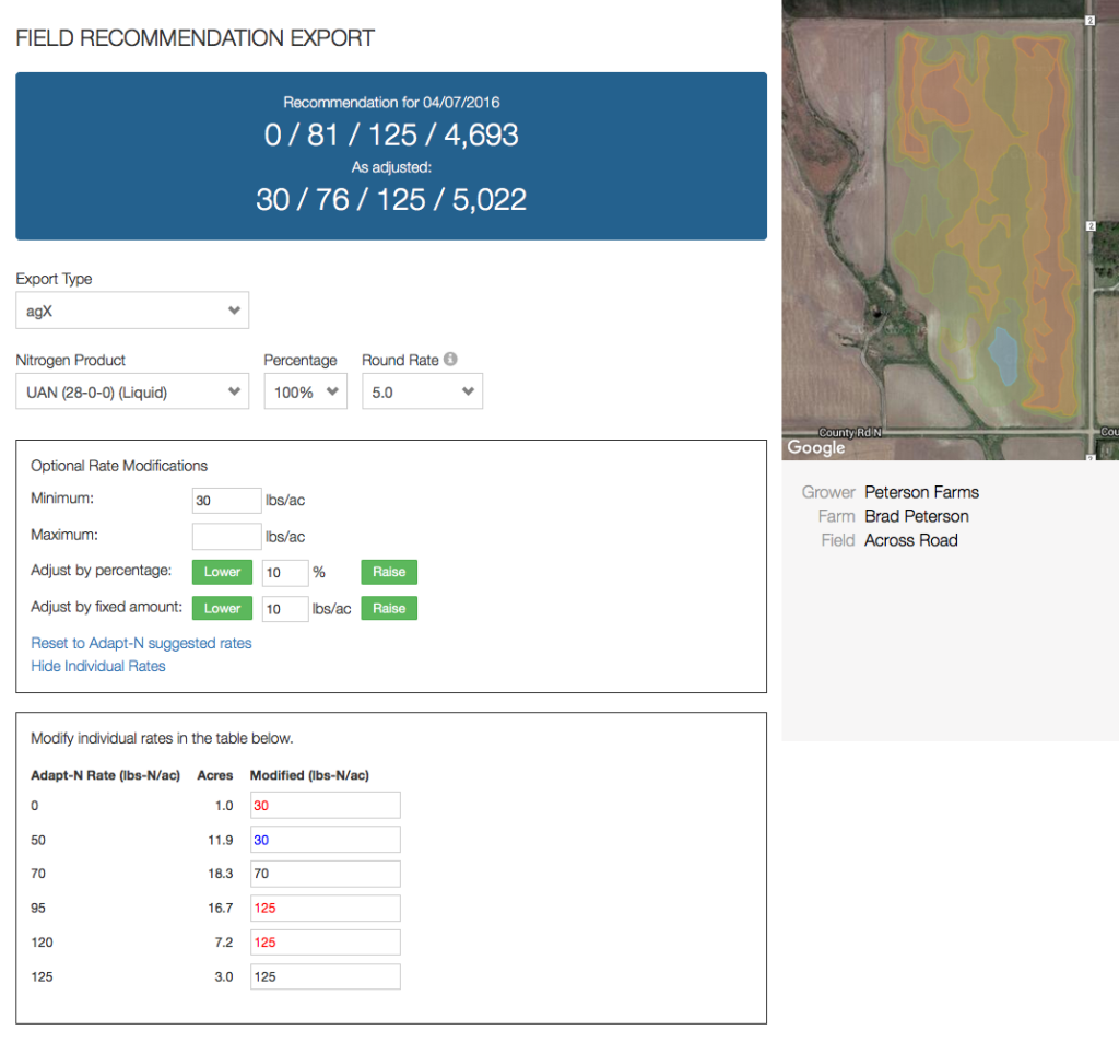
agX Integration Updates
Click here for additional documentation articles on our agX Integration.
We’ve improved the agX experience through the following updates:
- the field import process has been streamlined to function much more quickly
- Management zones in agX can now be used to automatically create zones in Adapt-N. Yield Goals on Management Zones in agX can also be automatically used to set variable yield goals in Adapt-N.
- A bulk import tab is now available, letting you import many fields at once
- The soil organic matter sync now goes back 5 seasons, and also automatically sets sample depth in addition to SOM percent
Crop multi-zone edit application now more flexible
The Crop multi-zone/multi-field application is much easier to use now, since the values on it have become optional. This lets users change one or more crop parameters across many fields at once without overwriting other existing crop parameters already set on those zones. For example, you can now set the planting date across many zones without overwriting yield data. The Previous Crop options have been adjusted to be clearer with respect to forage-sod crops. Users can also move between multi-zone editing sections using the new menu at the top of the screen.
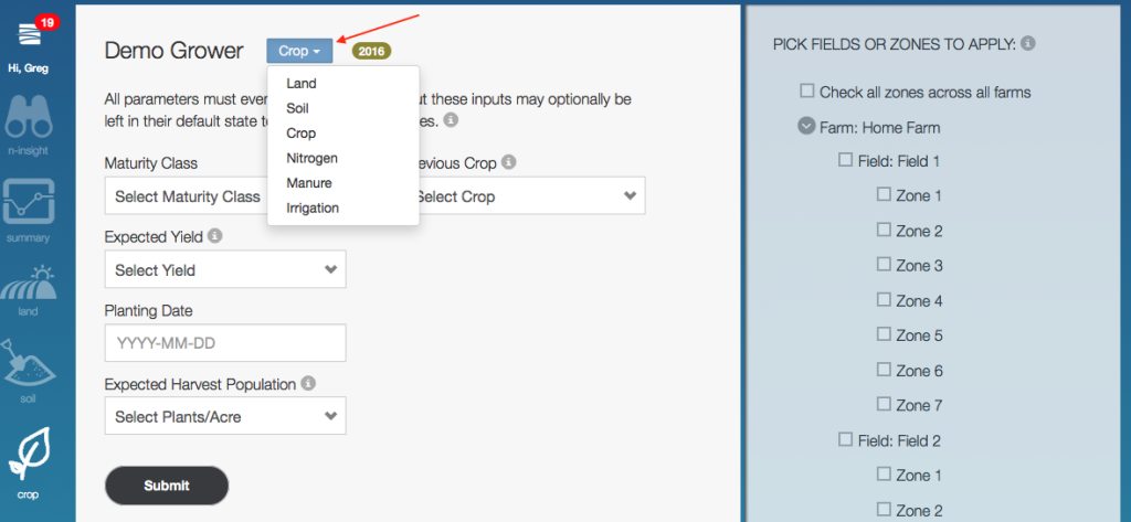
Expanded Service Territory
Adapt-N is now available for use in an expanded service territory. The system has been calibrated and deployed for use in the following new states for 2016:
- Alabama
- Arkansas
- Colorado
- Florida
- Georgia
- Louisiana
- Mississippi
- Oklahoma
- Tennessee
- Texas
Our service territory is now:
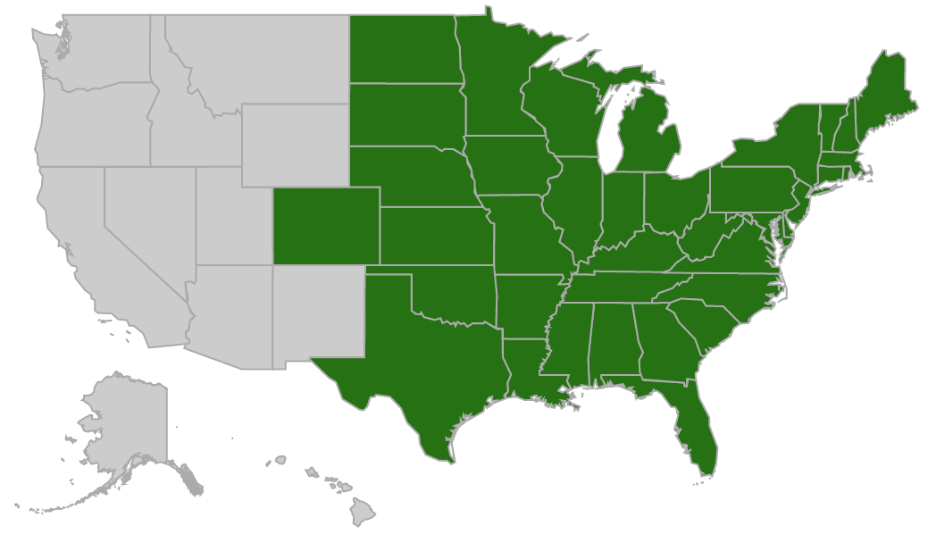
-
Spring 2016 Release Notes
The feature highlights below have been added to Adapt-N during the Spring of 2016.
Enhanced Field Recommendation Export Editor
During the recommendation export process, users now have much more fine grained control of product rounding, rates, minimums, maximums, and can dynamically see the impact of their changes on the overall recommendation (min, average, max, total pounds N).
Field Recommendation Summary Report PDF
When viewing the Field Recommendation, a PDF Report is available for download. Previously, PDFs were only available for individual zone recommendations and as part of the Field Recommendation Export.
Change Field Mode Tool
This tool now lets users switch reset a fields mode between point, zone, and grid options, with the ability to use all automatic zone creation options that would have originally been displayed during the field’s original created.
Point-Based GIS Files Accepted for Additional Layers
Previously, polygon-based shapefiles were accepted for all variable layers, and only Soil Organic Matter accepted point-based data. While polygon-based data is still recommended for all variable layers, enhancements were made to also accept point-based data for harvest population, expected yield, nitrogen application layers, and nitrate observation data layers. Please note that as-applied data submitted in point form may require additional processing time, especially when there are over 5,000 points in the file.
Advanced Rooting Depth Configuration Options
Users can now flexibly adjust rooting depth values from the Configure Field interface, either using a Shapefile or by increasing/decreasing values across the field. Rooting depth is an important agronomic input to confirm, as different management practices can have a significant impact on the crop’s rooting depth.
Zone Recommendation Yield Scenarios
Users can compare different yield goal scenarios while looking at an individual zone’s recommendation. Up to 2 additional yield goals for a zone can be selected, and Adapt-N will present side-by-side comparisons based on the simulation date specified. A comparison PDF report is also available.
Observations for Crop Emergence Data
Users can enter the observed crop emergence date and the growth model will adjust accordingly.
Observations for Nitrate Levels
Users can enter observed nitrate levels, to cause the model to re-calibrate as of the date of the test.
Variable Rate Irrigation Applications Supported
Users can now upload Shapefiles to specify variable rate irrigation applications.
Promoted articles
-
Nitrate Sampling Protocol and Recommendations
Soil Nitrate Test Observation
Adapt-N’s Virtual PSNT (sometimes called LSNT) provides simulated nitrate levels in the top 12” of the soil on a daily basis throughout the season. This helps reduce or even eliminate the need for extensive PSNT sampling.
Users who nevertheless are sampling for soil nitrate levels in the field to enhance the Adapt-N simulations can enter those test results as an Observation into Adapt-N. This adjusts the soil nitrate levels for the date of the test, and subsequently adjusts Adapt-N’s simulations. Explicit nitrate PPM values can be utilized, which cause Adapt-N's nitrate value as of the date and depth of the test to be changed to the user-supplied value, with subsequent daily simulations continuing from that point forward. Or, relative values can be supplied using the Nitrate Adjustment factor. The Nitrate Adjustment factor allows the user to supply a relative percentage by which Adapt-N's inherent nitrate PPM calculations as of a given date and depth will be modified. These observations can be supplied either at the zone level, or via the Field Configuration tool.
Example single-zone observation setting an explicit nitrate value to 10 ppm:
Example single-zone observation using a Nitrate Adjustment Factor to increase the zone's nitrate value by 15% as of the date and depth supplied:
In the above example, if Adapt-N's inherent nitrate simulation on 2018-05-01 was 10 ppm, this would cause the nitrate value to be raised to 15ppm. 15ppm would then be the new baseline moving forward, for future-date simulations.
Recommended Sampling Methodology
Soil nitrate tests are inherently variable, so it’s important to follow guidelines to minimize sampling bias and to maximize the consistency of results. Sampling strategies should be well thought out, documented, and consistently used. Give consideration to the management practices to ensure the sampling effort accurately captures variability within the field.
- PSNT samples should be taken when the corn plants are between 6 and 12 inches tall.
- Weather - make sure necessary precautions or adjustments are made if sampling around rainfall events. Significant rainfall prior to sampling can cause spatial variability in results. This can inaccurately depict losses of applied N fertilizer resulting in excess N being applied. Try to avoid sampling while the field is very wet or within 3 days of a high rainfall event.
- Sample the top 12 inches of the soil profile (the standard depth for PSNT). With early season rainfall events, N below the 1 ft level could very well be lost before the roots reach it.
- Samples should be from representative areas within a field: take management zones, soil textures, or other forms of spatial variation into account when determining where to sample. If possible, log GPS coordinates of sampling locations for future reference.
- Each sample should be based on a composite of multiple soil cores. Collect at least 10 cores per sample to represent a sampling area: Establish a consistent protocol to determine how many cores need to be included in a sample, and where those cores should come from. Balance the cores among row and between-row areas.
- Applications of banded (vs. broadcast) fertilizer or manure applications cause high spatial variability of soil nitrogen -- especially when applied in high amounts (e.g., through a large pre-plant injection). It is very difficult to get accurate PSNT estimates, because the results are highly dependent on whether soil cores were collected from the band or not. A consistent sampling protocol is needed to avoid introducing bias. We suggest the protocol available on this help page to address this challenge. An alternative approach is provided by N Watch https://nwatchonline.com/protocols.
- Handling & Shipping Samples: Talk to your soil lab for instructions on how to handle and ship samples as your lab may have a specific protocol to follow to ensure accurate results. Samples should be sent off as soon as possible after sampling.
- Interpretation of Soil Analysis: We found that Adapt-N’s Virtual PSNT tool does a good job at estimating real field values. But due to the expected high variability of PSNT sample results -- especially with manure and large banded fertilizer applications -- you may see some discrepancies between the measured values and Adapt-N’s virtual PSNT estimates. Our field trail data has shown Adapt-N to generally be within 5 ppm of the measured value.
- Once you interpreted the results, you will need to be confident of their accuracy before implementing them into your N strategy. Adapt-N takes these results at face value and makes no determination on their accuracy. If you have concerns over sampling analysis, talk to your soil lab before utilizing results.
Source: N-Watch -
Planting 2017 Release Notes
Welcome back to Adapt-N for the 2017 Season! This post contains highlights of key updates to the system. Don’t hesitate to reach out to support@adapt-n.com with any questions.
New training videos available
When you first log in, you’ll see a set of updated training videos, appropriate for both new and experienced users. Consider taking a few minutes to see recorded demonstrations of Adapt-N, showcasing many of these new features.
Field Rec Export Tool Enhancements
The Field Recommendation Export tool has a new feature which lets you select a maximum application rate for the primary nitrogen product. If a second nitrogen product is selected, the remainder of the full N rec for a given part of the field will be allocated to that product automatically. A good example is if you want to apply a maximum of 5 gal/ac of a custom product, but parts of your field call for more Nitrogen than would be provided by 5 gallons. This configuration would accomplish that objective:
Three other updates have also been made to this tool:
- When choosing a Shapefile as the export type, you can customize the name of the exported file.
- The percentage for the Remaining Nitrogen Product now automatically adjusts if you select a percentage below 100% for the primary Nitrogen Product.
- The PDF included with the exported Shapefile now has map colors that correspond with the adjusted recommendation, as opposed to the original recommendation.
Change Field Mode Tool Supports All Options
When looking at the Fields & Zones view, click the Field menu and select Change Field Mode if you’d like to adjust or reset the zone management approach to an existing field. This tool has been updated to provide the full suite of configuration options that exist when creating a field from scratch. This includes all three field modes (point-based, zone-based, grid-based), as well as all zone creation options:
- None: you’ll draw your zones by hand.
- Single Zone: create one zone for the whole field.
- By Soil Type: use the soil survey database to create zones.
- Shapefile: select a shapefile for use in creating management zones (you can also choose an attribute from the shapefile for zone names, and can optionally choose whether to combine management zones of identical names).
- Management Zones: if the field is connected to an external system and Management Zones exist in that system, this button will show up. When pressed, a list of Available Management Zones will be displayed.
Note that when using the Change Field Mode tool, the new field needs to be fully configured (configuration data other than Boundary do not carry over from the source field, as differences in zone geometry result in different spatial interpretations of source configuration data).
Variable Rate Manure Application Support
Users applying manure at variable rates throughout the field, or users who utilize more than one source of manure on a given field, can now upload Shapefiles via the Field Config tool. This feature functions in a similar fashion to the existing support for variable rate existing nitrogen applications and variable rate irrigation applications.
Zone Stats on Field Recommendation Page
Users looking at a field recommendation can now see a summary of various zone recommendation statistics, including N Loss, Mineralization, Uptake, Virtual PSNT, and more. These show the min, average, and max values for the same output parameters shown on the individual zone recommendation detail pages.
New Integration Available:
Adapt-N has released an initial integration with the John Deere Operations Center. Please contact support@adapt-n.com if you would like it enabled on your account. The integration lets users import field boundaries from John Deere Operations Center, and subsequently transmit completed Adapt-N recommendations back to John Deere Operations Center’s File page. Users who have authenticated with the John Deere Operations Center will be able to upload Adapt-N recommendations to Operations Center from any field, not just those originally imported from John Deere. Future enhancements are planned.
Integration Updates
Field import methods across agX and Agrian integrations have been standardized, so that the same options exist for single- and bulk-field import options. These enhancements include:
- User preferences enabling the automatic syncing of soil survey, soil organic matter, and soil pH data (when available) at the time of field creation.
- Ability to fully configure fields (grid-based fields included) while importing multiple fields at once with the Bulk Import tab. This is a great way to get your fields ready to go, then come back and tweak them individually as needed.
Integration Updates
EFC Systems' FieldAlytics product has completed a full integration with the Adapt-N API. This enables FieldAlytics users to create powerful variable rate Adapt-N recommendations without ever leaving their native interface. Contact EFC Sytems support for additional questions.
Agronomic Modeling Enhancements
The Adapt-N research team continually makes optimizations and improvements to the underlying scientific modeling based on research efforts, strip trial results, and observations from users. Highlights of this year’s enhancements include:
- Addition of Soil pH as an optional configuration input.
- Improvements to the way mineralization is simulated in very high organic matter soils.
- Addition of Previous Crop options for Wheat.
- Addition of an "Additional N Credits" value on recommendations, showing the explicit outputs from manure and previous crops.
Recap of Previous Updates
If you missed some of our previous updates, here are highlights of some of our more popular enhancements from 2016:
- Training Mode enables users to run prior-season recommendations at no charge.
- Crop Emergence and Soil Nitrate Observations can be entered to improve calibration of the model.
- Modifying Recommendation Parameters enable local conditions to be used for for crop prices, nitrogen costs, and pounds of N needed per expected bushel of yield.
- Adjusting Rooting Depth based on field observations improves the accuracy of modeled N losses during the season.
- Read the full release notes from January 2017
-
January 2017 Release Notes
Welcome back to the 2017 season! Over the last few months we've released a number of improvements and new features to Adapt-N, based on user feedback, suggestions, and agronomic research. If you have questions about any of these release notes, please email support@agronomic.com.
N-Insight
N-Insight is now available for all customers. Access the tool via the N-Insight logo, located in the left navigation bar; it is accessible to Billing Admin and Agronomist Users. A PDF report has also been added, accessible from any completed N-Insight report. Billing Admins who wish to customize the timing, form, and placement of nitrogen applications within N-Insight should contact support, as these parameters can be set for all N-Insight fields in an account.
Training Mode Feature
Training Mode is a new feature that lets users run example recommendations using prior-year weather data at no charge, for the purposes of training new users and demonstrating Adapt-N to growers. All Billing Admins have this feature turned on by default, and they can choose to subsequently enable it for other users in their account. Click here for full details.
Nitrogen Recommendation Updates
- The Field Recommendation Page now includes a new set of statistics, summarizing a number of modeling outputs for the field's zones:
- The Export Recommendation application now lets users modify the names of a shapefile prior to completing the export. Additionally, Foliar products are now supported as a special type of Custom Fertilizer; contact support to set these up. See full details here.
- When viewing a Zone's Recommendation Details (accessed by clicking on a zone from the Field Recommendation map), a Yield Scenarios option is available at the top, next to the date selector. This lets users generate a side-by-side comparison nitrogen recommendation for that zone, under 3 different expected yield scenarios. A PDF export option is also available for this tool.
Modeling Enhancements
- Optional Observational values are now accepted by Adapt-N, and are utilized to improve calibration of the models. Specifically:
- Crop emergence date can be provided to re-calibrate Adapt-N's growth model as of the date of the observation
- Soil nitrate test results can be provided, either on a flat or spatial basis, to cause Adapt-N's soil nitrate values to be re-calibrated as of the date and depth of the lab test. Users who have performed side-by-side testing of Adapt-N's Virtual PSNT and traditional lab nitrate tests have found strong correlation. However, deviations can be used as a trigger to review field inputs for accuracy, or observational values can be loaded into Adapt-N to cause a modest adjustment. Please note that research shows that in-field soil nitrate tests are inherently variable.
- Users can now control the pounds of Nitrogen needed per expected bushel of yield. This directly impacts the "expected N in crop at harvest" value seen on the recommendation detail page, which is otherwise calculated based on expected yield. Adapt-N accepts values from 0.9 to 1.2. In the absence of an explicit value being set, Adapt-N's system defaults will be used. Click here for additional details.
- Adapt-N utilizes a set of economic parameters in calculating a risk/profit adjustment that impacts the final recommendation. We've now provided the ability for users to adjust two of these parameters: Price of grain per bushel, and Cost of nitrogen per pound. Click here for additional details. Feature summary;
- Billing Admins can set these values for their entire account, and optionally can also set them for a specific Grower.
- When set, recommendation pages will clearly show which parameters were used. In the absence of these values being set, Adapt-N system defaults will be used.
- In the past, the start date of an Adapt-N simulation was adjusted based on various parameters of the field. This created some inconsistencies in how nitrogen losses would be accumulated in cases when unusual weather patterns were observed at the very end of a calendar year and when the field's parameters would not cause the simulation to start until January 1st. After completing an extensive research effort on this topic, we have modified Adapt-N such that all simulations will begin on November 1st, unless a nitrogen or manure application for the current season occurred prior to that date, in which case the simulation will begin on that date. In most cases, this change will have only a trivial impact on the recommendation. However, in cases where there were excessive rains and/or warm conditions in November and December, this change will ensure that those weather events are properly captured.
- As we've done for years between seasons, we've updated various parameters in our soil, crop, and climate models to optimize performance based on recent lab and field trial data.
Integration Update
- agX Platform / SST Software updates:
- Two new user preferences are now available on the Account tab of the agX Settings page:
- Set soil texture and slope based on Soil Survey information.
- Always attempt to sync Soil Organic Matter values from agX.
- Depending on the user preferences set above, when fields are imported Adapt-N will automatically set soil texture and slope, and will automatically pull the most recent soil test result from agX (must be within the last 5 seasons). Users can subsequently override these values through the normal configuration methods.
- Agrian updates:
- Saved management zones from Agrian can now be utilized for zone creation in Adapt-N at the time of field creation.
- A bulk import tool has been added, letting users import multiple fields at once.
- Two new user preferences are now available on the Account tab of the Agrian Settings page:
- Set soil texture and slope based on Soil Survey information.
- Always attempt to sync Soil Organic Matter values from Agrian.
- Depending on the user preferences set above, when fields are imported Adapt-N will automatically set soil texture and slope, and will automatically pull the most recent soil test result from Agrian (must be within the last 5 seasons). Users can subsequently override these values through the normal configuration methods.
- EFC Systems / FieldAlytics updates:
- Users can now access Adapt-N features directly from within FieldAlytics interface. This includes the ability to enroll fields, configure spatial layers, and run Adapt-N recommendations. Users should work entirely from within the FieldAlytics system and do not need to login to Adapt-N for these features.
- N-Insight will also soon be added to the FieldAlytics system.
- Contact EFC Systems support for further assistance on this integration.